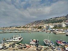
Tripoli District, Lebanon
Appearance
Tripoli District | |
|---|---|
District | |
 A neighborhood in east Tripoli | |
| Coordinates: 34°26′N 35°51′E / 34.433°N 35.850°E | |
| Country | |
| Governorate | North Governorate |
| Capital | Tripoli |
| Area | |
| • Total | 17 sq mi (45 km2) |
| Population | |
| • Total | 310,980[1] |
| Time zone | UTC+2 (EET) |
| • Summer (DST) | UTC+3 (EEST) |
The Tripoli District is a small, but very densely populated district in the North Governorate of Lebanon. It consists of the city Tripoli and the surrounding area. The vast majority of residents are Sunni Muslim (approximately 80%), a small minority Orthodox and Maronite Christians, and a small minority of Alawite Muslims.

Municipalities
Denominational makeup of the population
By registed voters in the district.
| Total | 232,940 |
| Denominations | Percentage |
|---|---|
| Christians | 9.12% |
| Maronites | 2.25% |
| Greek Orthodox | 5.18% |
| Greek Catholic | 0.63% |
| Armenian | 0.86% |
| Protestants | 0.2% |
| Muslims | 89.9% |
| Sunnis | 81.9% |
| Shiites | 1.18% |
| Druzes | 0.01% |
| Alawites | 6.8% |
References
- ^ "Tripoli District". Localiban.org. Centre de resources sur le développement local au Liban. Retrieved 29 December 2015.
- ^ http://lebanonelectiondata.org/confessions.html

