San Andres station
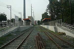
 Trackbed and platform area of San Andres station | |||||||||||
| General information | |||||||||||
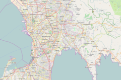
| Location | South Luzon Expressway cor. San Andres Street San Andres, Manila Philippines | ||||||||||
| Coordinates | 14°34′22.60″N 120°59′58.65″E / 14.5729444°N 120.9996250°E | ||||||||||
| Owned by | Philippine National Railways | ||||||||||
| Line(s) | █ PNR Southrail | ||||||||||
| Platforms | Side platforms | ||||||||||
| Tracks | 2 | ||||||||||
| Construction | |||||||||||
| Structure type | At grade | ||||||||||
| Accessible | Yes | ||||||||||
| Other information | |||||||||||
| Station code | SAN | ||||||||||
| History | |||||||||||
| Opened | March 24, 2010 | ||||||||||
| Services | |||||||||||
| |||||||||||
| |||||||||||
PNR Metro Commuter | ||||||||||||||||||||||||||||||||||||||||||||||||||||||||||||||||||||||||||||||||||||||||||||||||||||||||||||||||||||||||||||||||||||||||||||||||||||||||||||||||||||||||||||||||||||||||||||||||||||||||||||||||||||||||||||||||||||||||||||||||||||||||||||||||||||||||||||||||||||||||||||||||||||||||||||||||||||||||||||||||||||||||||||||||||||||||||||||||||||||||||||||||||||||||||||||||||||||||||||||||||||||||||||||||||||||||||||||||||||||||||||||||||||||||||||||||||||||||||||||||||||||||||||||||||||||||||||||||||||||||||||||||||||||||||||||||||||||||||||||||||||||||||||||||||||||||||||||
|---|---|---|---|---|---|---|---|---|---|---|---|---|---|---|---|---|---|---|---|---|---|---|---|---|---|---|---|---|---|---|---|---|---|---|---|---|---|---|---|---|---|---|---|---|---|---|---|---|---|---|---|---|---|---|---|---|---|---|---|---|---|---|---|---|---|---|---|---|---|---|---|---|---|---|---|---|---|---|---|---|---|---|---|---|---|---|---|---|---|---|---|---|---|---|---|---|---|---|---|---|---|---|---|---|---|---|---|---|---|---|---|---|---|---|---|---|---|---|---|---|---|---|---|---|---|---|---|---|---|---|---|---|---|---|---|---|---|---|---|---|---|---|---|---|---|---|---|---|---|---|---|---|---|---|---|---|---|---|---|---|---|---|---|---|---|---|---|---|---|---|---|---|---|---|---|---|---|---|---|---|---|---|---|---|---|---|---|---|---|---|---|---|---|---|---|---|---|---|---|---|---|---|---|---|---|---|---|---|---|---|---|---|---|---|---|---|---|---|---|---|---|---|---|---|---|---|---|---|---|---|---|---|---|---|---|---|---|---|---|---|---|---|---|---|---|---|---|---|---|---|---|---|---|---|---|---|---|---|---|---|---|---|---|---|---|---|---|---|---|---|---|---|---|---|---|---|---|---|---|---|---|---|---|---|---|---|---|---|---|---|---|---|---|---|---|---|---|---|---|---|---|---|---|---|---|---|---|---|---|---|---|---|---|---|---|---|---|---|---|---|---|---|---|---|---|---|---|---|---|---|---|---|---|---|---|---|---|---|---|---|---|---|---|---|---|---|---|---|---|---|---|---|---|---|---|---|---|---|---|---|---|---|---|---|---|---|---|---|---|---|---|---|---|---|---|---|---|---|---|---|---|---|---|---|---|---|---|---|---|---|---|---|---|---|---|---|---|---|---|---|---|---|---|---|---|---|---|---|---|---|---|---|---|---|---|---|---|---|---|---|---|---|---|---|---|---|---|---|---|---|---|---|---|---|---|---|---|---|---|---|---|---|---|---|---|---|---|---|---|---|---|---|---|---|---|---|---|---|---|---|---|---|---|---|---|---|---|---|---|---|---|---|---|---|---|---|---|---|---|---|---|---|---|---|---|---|---|---|---|---|---|---|---|---|---|---|---|---|---|---|---|---|---|---|---|---|---|---|---|---|---|---|---|---|---|---|---|---|---|---|---|---|---|---|---|---|---|---|---|---|---|---|---|---|---|---|---|---|---|---|---|---|---|---|---|---|---|---|---|---|---|---|---|---|---|---|---|---|---|---|---|---|---|---|---|---|---|---|---|---|---|---|---|---|---|---|---|---|---|---|---|---|---|---|---|---|---|---|---|---|
| ||||||||||||||||||||||||||||||||||||||||||||||||||||||||||||||||||||||||||||||||||||||||||||||||||||||||||||||||||||||||||||||||||||||||||||||||||||||||||||||||||||||||||||||||||||||||||||||||||||||||||||||||||||||||||||||||||||||||||||||||||||||||||||||||||||||||||||||||||||||||||||||||||||||||||||||||||||||||||||||||||||||||||||||||||||||||||||||||||||||||||||||||||||||||||||||||||||||||||||||||||||||||||||||||||||||||||||||||||||||||||||||||||||||||||||||||||||||||||||||||||||||||||||||||||||||||||||||||||||||||||||||||||||||||||||||||||||||||||||||||||||||||||||||||||||||||||||||
San Andres station is a station of the South Main Line ("Southrail") of the Philippine National Railways. Like all PNR stations, this station is At grade. It is located at the intersection of Aviadores Street, San Andres Street and the South Luzon Expressway in San Andres, Manila.
San Andres station is the seventh station southbound from Tutuban.
History
The original San Andres station was opened around 1929 as a flagstop on the defunct Naic Line and closed in 1936.
A new San Andres station on the Main Line South was opened on March 24, 2010 for commuter services.
Nearby landmarks
The station is near the Singalong sub-district of San Andres, the Dagonoy Public Market and the St. Anthony's School, Manila. Further away from the station are the Br. Andrew Gonzalez Hall of De La Salle University, the Bureau of Plant Industry, Ermita, Puregold(Osmeña Highway) and the Manila Zoological and Botanical Garden.
Transportation links
San Andres station is accessible by jeepneys plying the San Andres route, as well as buses plying routes on the South Luzon Expressway. A LRT-1 station, Quirino Avenue, is located further up San Andres Street on the intersection with Taft Avenue.
Station Layout
| L1 Platforms |
Side platform, doors will open on the right | |
| Platform A | PNR Metro Commuter towards Tutuban (←) | |
| Platform B | PNR Metro Commuter towards Alabang (→) | |
| Side platform, doors will open on the right | ||
| L1 | Concourse/ Street Level |
Ticket Booths, Station Control, Shops,Dagonoy Public Market, St. Anthony's School-Manila, |

