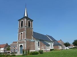
Bellaing
Appearance
Bellaing | |
|---|---|
 The church in Bellaing | |
| Coordinates: 50°22′09″N 3°25′36″E / 50.3692°N 3.4267°E | |
| Country | France |
| Region | Hauts-de-France |
| Department | Nord |
| Arrondissement | Valenciennes |
| Canton | Aulnoy-lez-Valenciennes |
| Intercommunality | Communauté d'agglomération de la Porte du Hainaut |
| Government | |
| • Mayor (2014-2020) | Michel Blaise |
| Area 1 | 3.42 km2 (1.32 sq mi) |
| Population (2021)[1] | 1,329 |
| • Density | 390/km2 (1,000/sq mi) |
| Time zone | UTC+01:00 (CET) |
| • Summer (DST) | UTC+02:00 (CEST) |
| INSEE/Postal code | 59064 /59135 |
| Elevation | 21–47 m (69–154 ft) (avg. 42 m or 138 ft) |
| 1 French Land Register data, which excludes lakes, ponds, glaciers > 1 km2 (0.386 sq mi or 247 acres) and river estuaries. | |
Bellaing is a commune in the Nord department in northern France.
Population
| Year | Pop. | ±% |
|---|---|---|
| 1800 | 182 | — |
| 1806 | 287 | +57.7% |
| 1821 | 338 | +17.8% |
| 1831 | 360 | +6.5% |
| 1836 | 395 | +9.7% |
| 1841 | 381 | −3.5% |
| 1846 | 384 | +0.8% |
| 1851 | 426 | +10.9% |
| 1856 | 378 | −11.3% |
| 1861 | 394 | +4.2% |
| 1866 | 374 | −5.1% |
| 1872 | 352 | −5.9% |
| 1876 | 362 | +2.8% |
| 1881 | 368 | +1.7% |
| 1886 | 422 | +14.7% |
| 1891 | 405 | −4.0% |
| 1896 | 403 | −0.5% |
| 1901 | 420 | +4.2% |
| 1906 | 405 | −3.6% |
| 1911 | 431 | +6.4% |
| 1921 | 414 | −3.9% |
| 1926 | 719 | +73.7% |
| 1931 | 747 | +3.9% |
| 1936 | 724 | −3.1% |
| 1946 | 677 | −6.5% |
| 1954 | 812 | +19.9% |
| 1962 | 941 | +15.9% |
| 1968 | 1,225 | +30.2% |
| 1975 | 1,298 | +6.0% |
| 1982 | 1,555 | +19.8% |
| 1990 | 1,335 | −14.1% |
| 1999 | 1,305 | −2.2% |
| 2006 | 1,240 | −5.0% |
| 2007 | 1,231 | −0.7% |
| 2008 | 1,222 | −0.7% |
| 2009 | 1,208 | −1.1% |
| 2013 | 1,168 | −3.3% |
| 2015 | 1,212 | +3.8% |
Heraldry
 |
The arms of Bellaing are blazoned : Quarterly 1&4: Argent, a fess sable; 2&3: Or, a cross moline sable. (Bellaing, Oisy and Preux-au-Bois use the same arms.)
|
See also
References
- ^ "Populations légales 2021" (in French). The National Institute of Statistics and Economic Studies. 28 December 2023.
Wikimedia Commons has media related to Bellaing.


