San Quintín Municipality
Appearance
San Quintín Municipality
Municipio de San Quintín | |
|---|---|
| Motto: ' | |
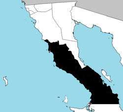
 Location of San Quintín in Baja California. | |
| Coordinates: 32°34′N 116°38′W / 32.567°N 116.633°W | |
| Country | |
| State | |
| Founded | 27 February 2020 |
| Seat | San Quintín |
| Largest city | San Quintín |
| Area | |
| • Total | 3,079.0 km2 (1,188.8 sq mi) |
| Data source: INEGI 2010 Census | |
| Time zone | UTC−8 (Northwest (US Pacific)) |
| • Summer (DST) | UTC−7 (Northwest) |
| INEGI code | 006 |
San Quintín is a municipality in the Mexican state of Baja California. Its municipal seat is located in the city of San Quintín, Baja California. According to the 2010 census, it had a population of inhabitants, and according to the 2005 census, it had 91,034 inhabitants. The municipality has an area of 3,079.0 km2 (1,188.8 sq mi).
History
On February 27, 2020 San Quintin separated from the municipality of Ensenada, and became the Baja California's sixth municipality.
Administrative divisions

The municipality is divided into 8 delegations: Camalú, Vicente Guerrero, San Quintín, El Rosario, El Mármol, Punta Prieta, Bahía de los Ángeles, and Villa Jesús María.
References

