
Lake Markakol
You can help expand this article with text translated from the corresponding article in Russian. (August 2012) Click [show] for important translation instructions.
|
| Lake Markakol Марқакөл | |
|---|---|
 | |
 Lake Markakol Марқакөл  Lake Markakol Марқакөл | |
 Map of the area | |
| Coordinates | 48°45′N 85°45′E / 48.750°N 85.750°E |
| Primary outflows | Kalzhyr |
| Basin countries | Kazakhstan |
| Max. length | 19 km (12 mi) |
| Max. width | 38 km (24 mi) |
| Surface area | 455 km2 (176 sq mi) |
| Average depth | 14 m (46 ft) |
| Max. depth | 30 m (98 ft) |
| Shore length1 | ~ 100 km (62 mi) |
| Surface elevation | 1,447 m (4,747 ft) |
| 1 Shore length is not a well-defined measure. | |
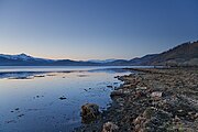
Lake Markakol (Kazakh: Марқакөл, Marqakól; Russian: озеро Маркаколь, ozero Markakol') is a lake in East Kazakhstan. The lake is fed with small rivers and streams. Its coasts are cut up by gulfs. It is the largest lake in the Katonkaragay District of East Kazakhstan Region. Its main outflow is the Kalzhyr, a tributary of the Irtysh.
Gallery
-
-

-
 The village of Urunkhayka on the east coast of Markakol.


Capital: Oskemen | ||
| Districts |  | |
| Major cities | ||
This Kazakhstan location article is a stub. You can help Wikipedia by expanding it. |