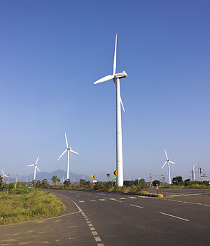
Muppandal Wind Farm
Appearance
| Muppandal Wind Farm | |
|---|---|
 | |
 Location of Muppandal Wind Farm in Tamil Nadu, India | |
| Country | India |
| Location | Muppandal - Aralvaimozhi, Kanyakumari district, Tamil Nadu |
| Coordinates | 8°15′0″N 77°35′24″E / 8.25000°N 77.59000°E |
| Status | Operational |
| Commission date | 1986 |
| Owner | Multiple |
| Wind farm | |
| Type | Onshore |
| Power generation | |
| Make and model | Suzlon NEG Micon Vestas Enercon |
| Nameplate capacity | 1,500 MW |
The Muppandal Wind Farm is India's largest operational onshore wind farm. This project located in Kanyakumari district, Tamil Nadu. The project was developed by Tamil Nadu Energy Development Agency. Its installed capacity is 1,500 MW, which makes it one of world's largest operational onshore wind farms.[1][2][3]
See also
References
- ^ Helman, Christopher. "Muppandal Wind Farm - pg.2". Forbes. Archived from the original on 13 April 2018. Retrieved 12 April 2018.
- ^ "Good wind season buoys Indowind Energy's financials". Retrieved 12 April 2018.
- ^ "The largest wind parks exceed 1 GW in size such as Gansu Wind Farm in China Muppandal Wind Park in India or Alta Wind Energy Center in USA" (PDF). World Energy Resources. World Energy Council. Archived (PDF) from the original on 31 March 2018. Retrieved 13 April 2018.
