
Les Autels
Les Autels | |
|---|---|
_landscape_and_city_limit_sign.JPG) Les Autels entrance and view | |
Location of Les Autels  | |
 Les Autels  Les Autels | |
| Coordinates: 49°45′51″N 4°13′33″E / 49.7642°N 4.2258°E | |
| Country | France |
| Region | Hauts-de-France |
| Department | Aisne |
| Arrondissement | Vervins |
| Canton | Vervins |
| Intercommunality | Portes de la Thiérache |
| Government | |
| • Mayor (2008–2020) | Eric Halle |
| Area 1 | 5.99 km2 (2.31 sq mi) |
| Population (2021)[1] | 62 |
| • Density | 10/km2 (27/sq mi) |
| Time zone | UTC+01:00 (CET) |
| • Summer (DST) | UTC+02:00 (CEST) |
| INSEE/Postal code | 02038 /02360 |
| Elevation | 178–260 m (584–853 ft) |
| 1 French Land Register data, which excludes lakes, ponds, glaciers > 1 km2 (0.386 sq mi or 247 acres) and river estuaries. | |
Les Autels is a commune in the department of Aisne in the Hauts-de-France region of northern France.
The inhabitants of the commune are known as Autelois or Auteloises.[2]
Geography
Les Autels is located some 35 km west of Charleville-Mézières and 10 km south of Aubenton. The northern and eastern borders of the commune are the departmental border between Aisne and Ardennes. Access to the commune is by the D1100 road from Brunehamel in the west which passes through the village and continues south to join the D530 south of the village. The D530 goes north in the commune changing to the D10B at the border and continues north to Blanchefosse-et-Bay. Apart from the village there is also the hamlet of Haut-Chemin south of the village. The commune is mostly farmland with some scattered forests.[3]
The Ruisseau du Moulin Bataille flows through the north of the commune towards the south-west forming part of the western border before continuing south to join the Serre near Mainbresson. An unnamed stream rises near the village and flows south-west to join the Ruisseau du Moulin Bataille.[3]
Neighbouring communes and villages[3]
Places adjacent to Les Autels | |
|---|---|
Administration
List of Successive Mayors[4]
| From | To | Name | Party | Position |
|---|---|---|---|---|
| 2001 | 2020 | Eric Halle |
(Not all data is known)
Demography
In 2010 the commune had 74 inhabitants. The evolution of the number of inhabitants is known from the population censuses conducted in the commune since 1793. From the 21st century, a census of communes with fewer than 10,000 inhabitants is held every five years, unlike larger towns that have a sample survey every year.[Note 1]
Template:Table Population Town
_paysage_avec_vue_sur_le_village.JPG)
_mairie.JPG)
_foyer_rural.JPG)

Sites and monuments
- The Church of Saint-Nicolas
- The War Memorial
- The Lavoir (Public laundry)
-
 The Church grounds
 -
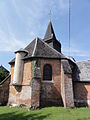 The Chevet of the Church of Saint-Nicolas
 -
 The Statue of Saint Nicolas in the church
 -
 Stained glass window of Saint Genevieve
 -
 Stained glass window
 -
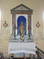 The Altar
 -
 Statue of Christ in the church
 -
 A Wayside Cross
 -
 The Nave
 -
 The War Memorial
 -
 The Lavoir
_%C3%A9glise_Saint-Nicolas.JPG)
_%C3%A9glise,_chevet.JPG)
_%C3%A9glise,_statue_Saint_Nicolas.JPG)
_%C3%A9glise,_vitrail_Sainte_Genevi%C3%A8ve.JPG)
_%C3%A9glise,_vitrail_ND_du_perp%C3%A9tuel_secours.JPG)
_%C3%A9glise,_petit_autel_de_la_Vierge.JPG)
_%C3%A9glise,_statue_Christ_au_liens.JPG)
_croix_de_chemin.JPG)
_%C3%A9glise,_int%C3%A9rieur,_nef.JPG)
_monument_aux_morts.JPG)
_lavoir.JPG)
See also
External links
- Les Autels on the old IGN website (in French)
- Les Autels on Lion1906
- Les Autels on Géoportail, National Geographic Institute (IGN) website (in French)
- Les Autels on the 1750 Cassini Map
Notes and references
Notes
- ^ At the beginning of the 21st century, the methods of identification have been modified by Law No. 2002-276 of 27 February 2002 Archived 6 March 2016 at the Wayback Machine, the so-called "law of local democracy" and in particular Title V "census operations" allows, after a transitional period running from 2004 to 2008, the annual publication of the legal population of the different French administrative districts. For communes with a population greater than 10,000 inhabitants, a sample survey is conducted annually, the entire territory of these communes is taken into account at the end of the period of five years. The first "legal population" after 1999 under this new law came into force on 1 January 2009 and was based on the census of 2006.
References
- ^ "Populations légales 2021" (in French). The National Institute of Statistics and Economic Studies. 28 December 2023.
- ^ Inhabitants of (in French)
- ^ a b c Google Maps
- ^ List of Mayors of France (in French)