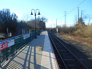
Amagansett station
Amagansett | |||||||||||
|---|---|---|---|---|---|---|---|---|---|---|---|
 The platform at Amagansett in November 2014, facing towards East Hampton. | |||||||||||
| General information | |||||||||||
| Location | Main Street & Abrahms Landing Road Amagansett, New York | ||||||||||
| Coordinates | 40°58′48″N 72°07′57″W / 40.98°N 72.1325°W | ||||||||||
| Owned by | Long Island Rail Road | ||||||||||
| Platforms | 1 side platform | ||||||||||
| Tracks | 1 | ||||||||||
| Connections | |||||||||||
| Construction | |||||||||||
| Parking | Yes | ||||||||||
| Bicycle facilities | Yes | ||||||||||
| Accessible | Yes | ||||||||||
| Other information | |||||||||||
| Fare zone | 14 | ||||||||||
| History | |||||||||||
| Opened | 1895 | ||||||||||
| Closed | 1909, 1964 | ||||||||||
| Rebuilt | 1910, 1965, 2001 | ||||||||||
| Passengers | |||||||||||
| 2012—2014 | 20[1] | ||||||||||
| Rank | 122 of 125 | ||||||||||
| Services | |||||||||||
|
Lua error in Module:Adjacent_stations at line 237: Unknown line "Montauk SFCC". | |||||||||||
| Former services | |||||||||||
| |||||||||||
Amagansett is a station on the Montauk Branch of the Long Island Rail Road, at Main Street (NY 27) and Abrahms Landing Road (former Suffolk CR 33A) in Amagansett, New York.
History

Amagansett station was opened on June 1, 1895, by the Brooklyn and Montauk Railroad, and closely resembled stations such as Sea Cliff and the former East Williston Depot, but lacked the second story and gingerbread woodwork trim that these depots contained. It was burned to the ground in 1909, reportedly by a disgruntled LIRR employee. The station was rebuilt on August 15, 1910, in the colonial barn style typical of stations such as Riverhead, Bay Shore, Northport, and Mineola. Until 1929, it had train sheds, a wye, and coal and water dispensing facilities. On June 13, 1942, Nazi saboteurs used Amagansett station en route to New York City for the failed mission known as Operation Pastorius.[2] The station house was closed in 1958 or January 1959, then razed on August 31, 1964, and replaced with a sheltered platform in 1965, a fact which has aroused disgust among railfans and local historians. The 1895-built former freight house survives, but was abandoned.[3] High-level platforms were added between 2000 and 2001, as many stations along the Long Island Rail Road were getting at the time.
Station layout
This station has one high-level platform on the south side of the single track, long enough for two cars to receive and discharge passengers.
| Track 1 | ← Montauk Branch toward Speonk, Jamaica, Long Island City, or Penn Station (East Hampton) Montauk Branch toward Montauk (Terminus) → |
| Side platform, doors will open on the left or right | |
References
- ^ "2012-2014 LIRR Origin and Destination Report : Volume I: Travel Behavior Among All LIRR Passengers" (PDF). Metropolitan Transportation Authority. 23 August 2016. PDF pp. 15, 199. Archived (PDF) from the original on 17 July 2019. Retrieved 29 March 2020.
Data collection took place after the pretest determinations, starting in September 2012 and concluding in May 2014. .... 2012-2014 LIRR O[rigin and ]D[estination] COUNTS: WEEKDAY East/West Total By Station in Numerical Order ... Amagansett
- ^ "Night of the Nazis (Montauk Life)". Archived from the original on 2015-12-18. Retrieved 2008-08-23.
- ^ Abandoned Freight House (Existing Railroad Stations in New York State)
External links
- Amagansett – LIRR
- Amagansett LIRR timetable
- Amagansett Station -- By Rail To The Sea (Arrt's Arrchives)
- Unofficial LIRR History Website
- Unofficial LIRR Photography Site (lirrpics.com)
