Mahad, Iraq
Mahad | |
|---|---|
Village | |
| Coordinates: 36°38′50″N 43°24′42″E / 36.64722°N 43.41167°E | |
| Country | |
| Region | |
| Governorate | Dohuk Governorate |
| District | Shekhan District |
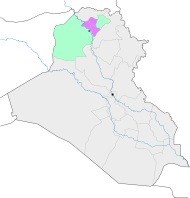
Mahad (Arabic: مهد; Kurdish: مەھەتێ ,Mehetê)[1][2] is a village located in the Shekhan District of the Dohuk Governorate of Kurdistan Region in Iraq. The village is located 9 kilometres (5.6 mi) southeast of Ain Sifni in the Nineveh plains.[3]
Mahad is populated by Yazidis.[4]
References
- ^ "4 welatiyên Êzidî li Duhokê jiyana xwe jidest dan". ROJ News (in Kurdish). Retrieved 19 December 2019.
- ^ "نڤيسينگەھا لالش مەھەتێ هاريكارى بسەر خێزانێن ھەژار بهلاڤكرن". p. ku. Retrieved 19 December 2019.
- ^ Saadi Azuo, Heerish (June 2016). "Graduate school of social sciences general psychology master's programme: Post-traumatic stress disorder among Ezidian women who escaped from ISIS capture" (PDF). Near East University. Retrieved 2018-12-05.
- ^ Toperich, Sasha; Ivanovic, Tea (2017). Zagros, Nahro (ed.). "Iraqi Kurdistan Region - A Path Forward" (PDF). Center for Transatlantic Relations - The Paul H. Nitze School of Advanced International Studies (Johns Hopkins University). Washington, DC: Center for Transatlantic Relations.


