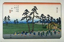
Kanō-juku


Kanō-juku (加納宿, Kanō-juku) was the fifty-third of the sixty-nine stations of the Nakasendō. It is located just south of JR Gifu Station in Gifu, Gifu Prefecture, Japan. During the Edo period, it was an independent post town that was approximately 2.3 km (1.4 mi) wide,[1] making it the largest post towns in Mino Province.[2][3][4]
Kanō Tenman-gū is located in the former Kanō-juku and was built in concurrence with Kanō Castle shortly after the Battle of Sekigahara. It was originally built to serve as a place of worship for the castle's residents, but it eventually became a place of prayer for many people within the growing post town.[1]
Princess Kazu stayed at Kanō-juku in 1861.
Neighboring post towns
- Nakasendō
- Unuma-juku - Kanō-juku - Gōdo-juku
- (Shinkanō-juku was an ai no shuku located between Unuma-juku and Kanō-juku.)
References
- ^ a b Gifu City Walking Map. Gifu Lively City Public Corporation, 2007.
- ^ Nakasendo to Shukuba-machi Archived 2007-08-13 at the Wayback Machine. Gifu City Hall. Accessed September 9, 2007.
- ^ http://www.ibisoku.co.jp/nakasenndou/kanou_Top.htm%E3%80%80Kan%C5%8D-juku. Retrieved 2020-02-13.
{{cite web}}: Missing or empty|title=(help)[dead link] - ^ Kanō-juku
