Seti Zone
Appearance
Seti
सेती अञ्चल | |
|---|---|
 | |
| Country | |
| Region | Far-Western (Sudur Pashchimanchal) |
| Capital | Dipayal |
| Time zone | UTC+5:45 (Nepal Time) |
| Main language(s) | Nepali, Dotali |
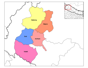
Seti (Template:Lang-neⓘ) was one of the fourteen zones located in the Far-Western Development Region of Nepal. Dhangadhi in the Terai is the major city of Seti Zone; headquarters are in Dipayal-Silgadhi. As of 2015, Nepal discontinued zone designations in favor of provinces; the area previously known as Seti Zone is now part of Sudurpashchim Pradesh.
Seti was divided into five districts:
| District | Type | Headquarters |
|---|---|---|
| Achham | Hill | Mangalsen |
| Bajhang | Mountain | Chainpur |
| Bajura | Mountain | Martadi |
| Doti | Hill | Silgadhi |
| Kailali | Outer Terai | Dhangadhi |
See also
- Development Regions of Nepal (Former)
- List of zones of Nepal (Former)
- List of districts of Nepal
29°15′N 81°10′E / 29.250°N 81.167°E
