
Roxana, Alabama
Roxana, Alabama | |
|---|---|
 Roxana United Methodist Church | |
 Roxana  Roxana | |
| Coordinates: 32°41′13″N 85°40′09″W / 32.68694°N 85.66917°W | |
| Country | United States |
| State | Alabama |
| County | Lee |
| Elevation | 738 ft (225 m) |
| Time zone | UTC-6 (CST) |
| • Summer (DST) | UTC-6 (EDT) |
| GNIS feature ID | 125999[1] |
Roxana, also known as Rock Springs, /rɒksænə/ is an unincorporated community northwesterly located in Lee County, Alabama, United States. It lies seven miles (12 km) north of Notasulga and five miles (8 km) southwest of Waverly. It is part of the Columbus, Georgia-Alabama Metropolitan Area.
History
Roxana was originally named Rock Springs. Since there was already a Rock Springs post office registered in Alabama, Samuel A. Burns, the first postmaster, devised a new name. He combined "rocks" and "Anna", the name of his wife, to come up with Roxana.[2] A post office operated under the name Roxana from 1882 to 1908.[3]
References
- ^ U.S. Geological Survey Geographic Names Information System: Roxana, Alabama
- ^ Foscue, Virginia (1989). Place Names in Alabama. Tuscaloosa: The University of Alabama Press. p. 121. ISBN 0-8173-0410-X.
- ^ "Lee County". Jim Forte Postal History. Retrieved 2 January 2015.
Municipalities and communities of Lee County, Alabama, United States | ||
|---|---|---|
| Cities | 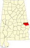 | |
| Towns | ||
| Unincorporated communities | ||
| Footnotes | ‡This populated place also has portions in an adjacent county or counties | |
| Central cities/largest cities |  Columbus, Georgia Metropolitan Statistical Area Auburn, Alabama Metropolitan Statistical Area Tuskegee, Alabama Micropolitan Statistical Area (defunct) | |
|---|---|---|
| Cities in Georgia | ||
| Cities in Alabama | ||
| Counties in Georgia | ||
| Counties in Alabama | ||
This Lee County, Alabama state location article is a stub. You can help Wikipedia by expanding it. |