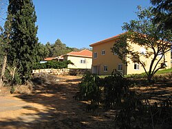
Kfar Pines
Appearance
Kfar Pines
כְּפַר פִּינֶס | |
|---|---|
 | |
| Etymology: Pines' Village | |
| Coordinates: 32°29′2″N 35°0′10″E / 32.48389°N 35.00278°E | |
| Country | |
| District | Haifa |
| Council | Menashe |
| Affiliation | Hapoel HaMizrachi |
| Founded | 1933 |
| Founded by | Eastern European immigrants |
| Population (2022)[1] | 1,102 |
Kfar Pines (Template:Lang-he, lit. Pines Village) is a religious moshav in northern Israel. Located to the north-east of Hadera, adjacent to Pardes Hanna-Karkur and Ein Iron, it falls under the jurisdiction of Menashe Regional Council. In 2022 it had a population of 1,102.[1]
History
The village was established in 1933 by Jewish immigrants from eastern Europe, and was named after the author Rabbi Yehiel Michal Pines. It hosts an ulpena, a religious girls high school, named "Ramat Karniel" (Karniel's height). It is the first ulpena in Israel and therefore it is called "Em HaUlpenot" (mother of all ulpenas).
References
- ^ a b "Regional Statistics". Israel Central Bureau of Statistics. Retrieved 21 March 2024.


