
Erice
Erice | |
|---|---|
| Città di Erice | |
 View of Erice | |
Location of Erice  | |
 Erice Location of Erice in Italy  Erice Erice (Sicily) | |
| Coordinates: 38°2′13″N 12°35′11″E / 38.03694°N 12.58639°E | |
| Country | Italy |
| Region | Sicily |
| Province | Trapani (TP) |
| Frazioni | Ballata, Casa Santa, Crocefissello, Napola, Pizzolungo, Rigaletta, San Cusumano, Torretta |
| Government | |
| • Mayor | Daniela Toscano |
| Area | |
| • Total | 47 km2 (18 sq mi) |
| Elevation | 751 m (2,464 ft) |
| Population (31 March 2020)[2] | |
| • Total | 27,465 |
| • Density | 580/km2 (1,500/sq mi) |
| Demonym | Ericini |
| Time zone | UTC+1 (CET) |
| • Summer (DST) | UTC+2 (CEST) |
| Postal code | 91016 |
| Dialing code | 0923 |
| Patron saint | SS. Mary of Custonaci |
| Website | Official website |
Erice (Italian pronunciation: [ˈɛːritʃe]; Sicilian: Èrici ) is a historic town and comune in the province of Trapani in Sicily, southern Italy.
Geography
The main town of Erice is located on top of Mount Erice, at around 750 metres (2,460 ft) above sea level, overlooking the city of Trapani, the low western coast towards Marsala, the dramatic Punta del Saraceno and Capo San Vito to the north-east, and the Aegadian Islands on Sicily's north-western coast. Casa Santa forms part of Erice at the base of Mount Erice, immediately adjacent to Trapani. A cable car joins the upper and lower parts of Erice.
The bordering municipalities are Buseto Palizzolo, Paceco, Trapani, Valderice and Custonaci. The hamlets (frazioni) are Ballata, Casa Santa, Crocefissello, Napola, Pizzolungo, Rigaletta, San Cusumano and Torretta.
History

The ancient Greek name of Erice was Eryx (Έρυξ in Greek), and its foundation was associated with the eponymous Greek hero Eryx. It was not a Greek colony, as the Phoenicians founded it, but was largely Hellenized. It was destroyed in the First Punic War by the Carthaginians, and from then on declined in importance.
Eryx was conquered by the Aghlebids in 831 and was renamed as Cebel Hamid (in Western sources Gebel Hamed, meaning Mountain of Hamid). It was ruled by the Arabs until the Norman conquest. In 1167 the Normans renamed it Monte San Giuliano, a name maintained until 1934.
Main sights
In the northeastern portion of the city there are the remains of ancient Elymian and Phoenician walls (Cyclopean masonry) indicating different stages of settlement and occupation in antiquity.
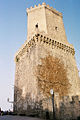
There are two castles that remain in the city: Pepoli Castle, which dates from Saracen times, and the Castello di Venere ("Venus Castle"), dating from the Norman period, built on top of the ancient Temple of Venus, where Venus Ericina was worshipped. According to legend, the temple was founded by Aeneas. It was well known throughout the Mediterranean area in the ancient age, and an important cult was celebrated in it. In his book On the Nature of Animals, Aelian writes that animals chosen for sacrifice would voluntarily walk up to the altar to be killed.
A cable car (funivia) ran from 2005 to 2017, when it was closed due to a forest fire, from the outskirts of Trapani to the town of Erice. The cablecar was rebuilt and reopened in June 2018.
Culture
Erice hosts scientific meetings at the Ettore Majorana center, organised by the controversial astrophysicist Antonino Zichichi. There is also an annual workshop on Molecular Gastronomy.[citation needed]
Gallery
-
 Erice Cathedral with its bell tower
 -
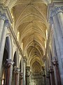 View inside the Cathedral
 -
 Rose window of the Cathedral
 -
 Cyclopean masonry
 -
 Via San Carlo
 -
 St Julian's Church
 -
 Castle of Balio
 -
 The stronghold and Castle of Venere
 -
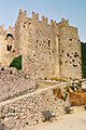 Castle of Venere
 -
 View of monte Cofano
 -
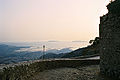 Trapani seen from the castle
 -
 Monte Cofano seen from an alley in Erice
.jpg)


External links


| International | |
|---|---|
| National | |
| Geographic | |
| Other | |
- ^ "Superficie di Comuni Province e Regioni italiane al 9 ottobre 2011". Italian National Institute of Statistics. Retrieved 16 March 2019.
- ^ "Popolazione Residente al 1° Gennaio 2018". Italian National Institute of Statistics. Retrieved 16 March 2019.