
Kimmirut
Kimmirut
ᑭᒻᒥᕈᑦ | |
|---|---|
 Kimmirut, Nunavut | |
 Kimmirut  Kimmirut | |
| Coordinates: 62°50′48″N 069°52′07″W / 62.84667°N 69.86861°W | |
| Country | Canada |
| Territory | Nunavut |
| Region | Qikiqtaaluk |
| Electoral district | South Baffin |
| Anglican mission | 1909 |
| Government | |
| • Mayor | Maliktuk Lyta |
| • MLA | David Joanasie |
| Area | |
| • Total | 2.27 km2 (0.88 sq mi) |
| Elevation | 53 m (174 ft) |
| Population (2016)[3] | |
| • Total | 389 |
| • Density | 171.7/km2 (445/sq mi) |
| Time zone | UTC−05:00 (EST) |
| • Summer (DST) | UTC−04:00 (EDT) |
| Canadian Postal code | |
| Area code | 867 |
| Website | www.kimmirut.ca |
Kimmirut (Syllabics: ᑭᒻᒥᕈᑦ IPA: [kimːiɢut]; known as Lake Harbour until 1 January 1996) is a community in the Qikiqtaaluk Region, Nunavut, Canada. It is located on the shore of Hudson Strait on Baffin Island's Meta Incognita Peninsula. Kimmirut means "heel", and refers to a rocky outcrop in the inlet.
It was at one time a Hudson's Bay Company trading post, and a Royal Canadian Mounted Police post. The Canadian explorer J. Dewey Soper used these posts as headquarters during his explorations in the 1920s and 1930s.
The community is served by Kimmirut Airport and by annual supply sealift. A proposal in 2005 for a road to Iqaluit was shown to be impractical owing to roundabout routing over the mountains.
As of the 2016 census the population was 389, a decrease of 14.5% from the 2011 census[3]
Image gallery
-
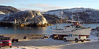 Boat launch in Kimmirut. The "heel" can be seen to the left. 2006
 -
 Hudson's Bay Company in Lake Harbour, 1922
 -
 Hudson's Bay Company, 2006
 -
 The Soper House dates back to the 1930s. 2006.
 -
 View of Kimmirut, 2006
 -
 View of Southeast Kimmirut, 2017

,_Baffin_Island_(1922).jpg)


Broadband communications
The community has been served by the Qiniq network since 2005. Qiniq is a fixed wireless service to homes and businesses, connecting to the outside world via a satellite backbone. The Qiniq network is designed and operated by SSI Micro. In 2017, the network was upgraded to 4G LTE technology, and 2G-GSM for mobile voice.
Climate
Kimmirut has an Arctic climate (Köppen: ET), although it is well outside the Arctic Circle. The city has cold winters and short summers that are too cool to permit the growth of trees. It is north of the tree line, and average monthly temperatures are below freezing for eight months of the year. Kimmirut averages just over 335 mm (13.2 in) of precipitation annually, wetter than many other localities in the Arctic Archipelago, with the summer being the wettest season.
| Climate data for Kimmirut | |||||||||||||
|---|---|---|---|---|---|---|---|---|---|---|---|---|---|
| Month | Jan | Feb | Mar | Apr | May | Jun | Jul | Aug | Sep | Oct | Nov | Dec | Year |
| Record high °C (°F) | 2.0 (35.6) |
4.0 (39.2) |
5.0 (41.0) |
7.0 (44.6) |
15.0 (59.0) |
26.0 (78.8) |
29.0 (84.2) |
31.0 (87.8) |
22.0 (71.6) |
18.0 (64.4) |
6.0 (42.8) |
3.0 (37.4) |
31.0 (87.8) |
| Mean daily maximum °C (°F) | −21.0 (−5.8) |
−21.0 (−5.8) |
−16.0 (3.2) |
−8.0 (17.6) |
0.0 (32.0) |
8.0 (46.4) |
13.0 (55.4) |
12.0 (53.6) |
6.0 (42.8) |
0.0 (32.0) |
−7.0 (19.4) |
−15.0 (5.0) |
−4.1 (24.6) |
| Daily mean °C (°F) | −26.0 (−14.8) |
−26.0 (−14.8) |
−21.5 (−6.7) |
−13.0 (8.6) |
−3.5 (25.7) |
4.5 (40.1) |
8.5 (47.3) |
8.0 (46.4) |
3.0 (37.4) |
−3.0 (26.6) |
−11.5 (11.3) |
−20.0 (−4.0) |
−8.37 (16.93) |
| Mean daily minimum °C (°F) | −31.0 (−23.8) |
−31.0 (−23.8) |
−27.0 (−16.6) |
−18.0 (−0.4) |
−7.0 (19.4) |
1.0 (33.8) |
4.0 (39.2) |
4.0 (39.2) |
0.0 (32.0) |
−6.0 (21.2) |
−16.0 (3.2) |
−25.0 (−13.0) |
−12.7 (9.1) |
| Record low °C (°F) | −45.0 (−49.0) |
−47.0 (−52.6) |
−44.0 (−47.2) |
−34.0 (−29.2) |
−24.0 (−11.2) |
−9.0 (15.8) |
−2.0 (28.4) |
−3.0 (26.6) |
−13.0 (8.6) |
−27.0 (−16.6) |
−36.0 (−32.8) |
−44.0 (−47.2) |
−47.0 (−52.6) |
| Average precipitation mm (inches) | 16.4 (0.65) |
14.5 (0.57) |
15.5 (0.61) |
24.0 (0.94) |
30.0 (1.18) |
30.0 (1.18) |
31.0 (1.22) |
40.4 (1.59) |
43.4 (1.71) |
34.9 (1.37) |
30.0 (1.18) |
25.4 (1.00) |
335.5 (13.21) |
| Source: MSN Monthly Averages and Records [5] | |||||||||||||
Notable residents
See also
References
- ^ Nunavummiut vie for council positions in upcoming hamlet elections
- ^ Results for the constituency of South Baffin Archived 2013-11-14 at the Wayback Machine at Elections Nunavut
- ^ a b c "Census Profile, 2016 Census Kimmirut". Statistics Canada. Retrieved 2017-03-03.
- ^ Elevation at airport. Canada Flight Supplement. Effective 0901Z 16 July 2020 to 0901Z 10 September 2020.
- ^ "Kimmirut, CAN". iMap by Singapore MSN Weather. Archived from the original on 2014-01-08. Retrieved 2014-01-08.
Further reading
- Fisher, Kyra Vladykov. Guide to Kimmirut Artists, 2005-2006. [Kimmirut]: Municipality of Kimmirut, 2005. ISBN 0-9739416-0-X
- Woodley, S. B. Community Based Tourism in Kimmirut, Baffin Island, Nunavut Regional Versus Local Attitudes. Ottawa: National Library of Canada = Bibliothèque nationale du Canada, 2001. ISBN 0-612-55010-9