Michigan Park (Washington, D.C.)
Michigan Park | |
|---|---|
 Michigan Park within the District of Columbia | |
| Coordinates: 38°56′54″N 76°59′09″W / 38.9483°N 76.9858°W | |
| Country | United States |
| District | Washington, D.C. |
| Ward | Ward 5 |
| Government | |
| • Councilmember | Kenyan McDuffie |

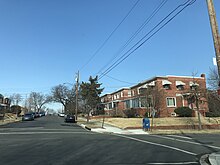
Michigan Park is a neighborhood in Ward 5 of Northeast Washington, D.C.[1] Michigan Park is contained between the Washington Metropolitan Area Red Line train tracks to the west, South Dakota Avenue N.E. to the east, Gallatin Street N.E. to the north and Taylor Street N.E. & Michigan Avenue N.E. to the South. Michigan Park borders the adjacent neighborhoods of Fort Totten, Queens Chapel, North Michigan Park, Pleasant Hill, University Heights, and Brookland in Ward 5 of Northeast Washington D.C.
The Michigan Park neighborhood is often confused with the North Michigan Park neighborhood and North Michigan Park Civic Association which has boundaries that include both Michigan Park and North Michigan Park. Additionally, Michigan Park completely contains the Queens Chapel Civic Association that is separate from the Queens Chapel neighborhood which borders Michigan Park to the north.
The Washington Metropolitan Area Red Line train tracks pass through the Michigan Park neighborhood when traveling between the Fort Totten and Brookland-CUA Metro Stations.
The Queens Chapel association meets regularly at Union Wesley African Methodist Zion Church and its boundaries are between 16th Street N.E. and Webster Street NE to the north, Michigan Avenue N.E. to the south, and South Dakota Avenue N.E. to the west. [citation needed]
References
- ^ "About Ward 5 | op". planning.dc.gov.
