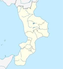
Montauro
Montauro | |
|---|---|
| Comune di Montauro | |
| Coordinates: 38°45′N 16°31′E / 38.750°N 16.517°E | |
| Country | Italy |
| Region | Calabria |
| Province | Catanzaro (CZ) |
| Frazioni | Montauro Scalo |
| Government | |
| • Mayor | Commissioner from Catanzaro Regional Office |
| Area | |
| • Total | 11.54 km2 (4.46 sq mi) |
| Elevation | 391 m (1,283 ft) |
| Population (March 2017)[2] | |
| • Total | 1,593 |
| • Density | 140/km2 (360/sq mi) |
| Demonym | Montaurese |
| Time zone | UTC+1 (CET) |
| • Summer (DST) | UTC+2 (CEST) |
| Postal code | 88060 |
| Dialing code | 0967 |
| Patron saint | San Pantaleone |
| Saint day | 27 July, 5 February |
| Website | Official website |
Montauro (Calabrian: Mentràvu) is a comune and town in the province of Catanzaro in the Calabria region of Italy. The municipalities of Gasperina, Montepaone, Palermiti, Squillace, Stalettì are nearby. Agricultural center of the Ionian coast of the greenhouses, in foothills sloping towards the Gulf of Squillace, North of the mouth of the river Soverato. Built before the year 1000, the village had name from the mountain on which it stands, felt with gold. In 1101 by Count Roger was given in fief to the carthusians of Serra San Bruno. Severely damaged by the earthquake of 1783, in 1846 he suffered other damage due to an exceptional flood. The parish church incorporates remains of medieval fortifications with its external structures; in the Interior, which currently occurs in the appearance given to him in the 17th century, wooden ceiling and choir ' 600, sumptuous altar in polychrome marble and bronze sculptures (of the Redeemer and the Apostles) and marble (Saints Peter and Paul) of 600-700 's. Near the village there are the ruins of the monastery of San Domenico, of Norman Foundation and destroyed by an earthquake in 1783.
Photo By Luca Mercurio
-
Montauro in Piazza
- ^ "Superficie di Comuni Province e Regioni italiane al 9 ottobre 2011". Italian National Institute of Statistics. Retrieved 16 March 2019.
- ^ "Popolazione Residente al 1° Gennaio 2018". Italian National Institute of Statistics. Retrieved 16 March 2019.


