Alexanderplatz


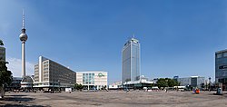
Alexanderplatz (pronounced [ʔalɛkˈsandɐˌplats] ) is a large public square and transport hub in the central Mitte district of Berlin, near the Fernsehturm. Berliners often call it simply Alex, referring to a larger neighbourhood stretching from Mollstraße in the northeast to Spandauer Straße and the Rotes Rathaus in the southwest.
History


Early history
Originally a cattle market outside the city fortifications, it was named in honor of a visit of the Russian Emperor Alexander I to Berlin on 25 October 1805 by order of King Frederick William III of Prussia. The square gained a prominent role in the late 19th century with the construction of the Stadtbahn station of the same name and a nearby market hall, followed by the opening of a department store of Hermann Tietz in 1904, becoming a major commercial centre. The U-Bahn station of the present-day U2 line opened on 1 July 1913.
Its heyday was in the 1920s, when together with Potsdamer Platz it was at the heart of Berlin's nightlife, inspiring the 1929 novel Berlin Alexanderplatz (see 1920s Berlin) and the two films based thereon, Piel Jutzi's 1931 film and Rainer Werner Fassbinder's 15½ hour second adaptation, released in 1980. About 1920 the city's authorities started a rearrangement of the increasing traffic flows laying out a roundabout, accompanied by two buildings along the Stadtbahn viaduct, Alexanderhaus and Berolinahaus finished in 1932 according to plans designed by Peter Behrens.
East Germany


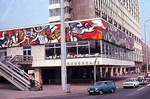
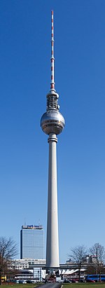
Alexanderplatz has been subject to redevelopment several times in its history, most recently during the 1960s, when it was turned into a pedestrian zone and enlarged as part of the German Democratic Republic's redevelopment of the city centre. It is surrounded by several notable structures including the Fernsehturm (TV Tower), the second tallest structure in the European Union.
Alex also accommodates the Park Inn Berlin and the World Time Clock, a continually rotating installation that shows the time throughout the globe, and Hermann Henselmann's Haus des Lehrers. During the Peaceful Revolution of 1989, the Alexanderplatz demonstration on 4 November was the largest demonstration in the history of East Germany.
After German reunification
Ever since German reunification, Alexanderplatz has undergone a gradual process of change with many of the surrounding buildings being renovated. Despite the reconstruction of the tram line crossing, it has retained its socialist character, including the much-graffitied "Fountain of Friendship between Peoples" (Brunnen der Völkerfreundschaft), a popular venue.
In 1993, architect Hans Kollhoff's master plan for a major redevelopment including the construction of several skyscrapers was published.[1] Due to a lack of demand it is unlikely these will be constructed, with the exception (announced January 2014) of a 39-storey residential tower designed by Frank Gehry on which work is expected to begin in 2015. However, beginning with the reconstruction of the Kaufhof department store in 2004, and the biggest underground railway station of Berlin, some buildings will be redesigned and new structures built on the square's south-eastern side. Sidewalks were expanded to shrink one of the avenues, a new underground garage was built, and commuter tunnels meant to keep pedestrians off the streets were removed.[1] The surrounding buildings now house chain stores, fast-food restaurants, and fashion discounters.[1] The Alexa shopping mall, with approximately 180 stores opened nearby during 2007 and a large Saturn electronic store was built and is open on Alexanderplatz since 2008. The CUBIX multiplex cinema, which opened in November 2000, joined in 2007 the team of Berlinale cinemas and the festival is showing films on three of its screens.[2]
Many historic buildings are located in the vicinity of Alexanderplatz. The traditional seat of city government, the Rotes Rathaus, or Red City Hall, is located nearby, as was the former East German parliament building, the Palast der Republik, demolition of which began in February 2006 and has been completed. The reconstruction of the Baroque Stadtschloss near Alexanderplatz has been in planning for several years.[3]
Alexanderplatz is also the name of the S-Bahn and U-Bahn stations there. It is one of Berlin's largest and most important transportation hubs, being a cross of 3 subway (U-Bahn) lines, 3 S-Bahn lines, and many tram and bus lines, as well as regional trains.
Image gallery
-
The World clock with the Fernsehturm in the background
-
Alexanderhaus
-
Project Blinkenlights
-
Park Inn with a reflection from the Fernsehturm.
-
Shopping mall die mitte
-
Bahnhof Alexanderplatz and the Fernsehturm
-
Tram at Alexanderplatz
-
Fernsehturm on "Alex"
-
The World clock and Park Inn hotel in the background
You can help expand this article with text translated from the corresponding article in French. (April 2015) Click [show] for important translation instructions.
|
You can help expand this article with text translated from the corresponding article in German. (April 2015) Click [show] for important translation instructions.
|
References
Further reading
- Weszkalnys, Gisa. Berlin, Alexanderplatz: Transforming Place in a Unified Germany (Berghahn Books; 2010) 214 pages
External links
![]() Media related to Alexanderplatz at Wikimedia Commons
Media related to Alexanderplatz at Wikimedia Commons


