
Arahata Fuji Shrine
| Arahata Fuji Shrine | |
|---|---|
 Arahata Fuji from below | |
| Religion | |
| Affiliation | Shinto (Japanese) |
| Prefecture | Saitama |
| Location | |
| Municipality | Tokorozawa |
| Prefecture | Saitama |
| Geographic coordinates | 35°46′25.84″N 139°26′45.01″E / 35.7738444°N 139.4458361°E |
Arahata Fuji Shrine (荒幡の富士神社, Arahata no Fuji Jinja) is a Shintō shrine in Tokorozawa city, Saitama Prefecture, Japan. It is noteworthy as a scale reproduction of Mount Fuji that can be easily climbed and offers views of the actual Mount Fuji and surrounding areas from the top.
History
Arahata Fuji was built in the 1880s by the local population at a time when visiting and climbing the actual Mount Fuji was out of the reach of most Japanese.[1]
Gallery
-
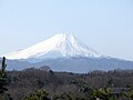 Mt Fuji From Arahata Fuji (with optical zoom)
 -
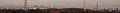 Tokyo Skyline from Arahata Fuji
 -
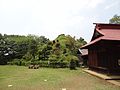 Park at base
 -
 View of Seibuen Amusement Park from the summit
 -
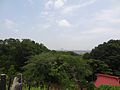 View of Downtown Tokorozawa from the summit
 -
 Meiji Period small shrine at the summit
 -
 Shrine story (in Japanese)
 -
 View of the Torii Gate from the summit


References
35°46′25.84″N 139°26′45.00″E / 35.7738444°N 139.4458333°E
This Saitama Prefecture location article is a stub. You can help Wikipedia by expanding it. |