
Artigues, Aude
Artigues | |
|---|---|
 | |
 Coat of arms | |
Location of Artigues  | |
| Country | France |
| Region | Occitania |
| Department | Aude |
| Arrondissement | Limoux |
| Canton | Axat |
| Intercommunality | Canton d'Axat |
| Government | |
| • Mayor (2008–2020) | Serge Mounié |
| Area 1 | 6.38 km2 (2.46 sq mi) |
| Population (2010) | 83 |
| • Density | 13/km2 (34/sq mi) |
| Time zone | UTC+01:00 (CET) |
| • Summer (DST) | UTC+02:00 (CEST) |
| INSEE/Postal code | 11017 /11140 |
| Elevation | 450 m (1,480 ft) |
| 1 French Land Register data, which excludes lakes, ponds, glaciers > 1 km2 (0.386 sq mi or 247 acres) and river estuaries. | |
Artigues is a French commune in the Aude department in the Occitanie region of southern France.
The inhabitants of the commune are known as Artiguais or Artiguaises.[1]
Geography

Artigues is located some 10 km south by south-east of Quillan and 2 km west of Axat. Access to the commune is by the D83 road from Axat in the east passing through the village and continuing west then south by a tortuous route to Le Clat. The commune is rugged and heavily forested but with a little farming activity near the village.[2]
The Aude River forms the south-eastern border of the commune as it flows north. The Ruisseau de l'Esteille rises in the south of the commune and flows east to join the Aude east of the commune. The Ruisseau de la Fage rises in the south of the commune and flows north to join the Ruisseau d'Artigues just south of the village which flows east to join the Aude.[2]
Neighbouring communes and villages[2]
Places adjacent to Artigues, Aude | |
|---|---|
Heraldry
|
The official status of the blazon remains to be determined
Blazon:
|
Administration
List of Successive Mayors[3]
| From | To | Name | Party | Position |
|---|---|---|---|---|
| 2001 | 2008 | Christian Domingo | ||
| 2001 | 2020 | Serge Mounié | PS |
(Not all data is known)
Demography
In 2010 the commune had 83 inhabitants. The evolution of the number of inhabitants is known from the population censuses conducted in the commune since 1793. From the 21st century, a census of communes with fewer than 10,000 inhabitants is held every five years, unlike larger towns that have a sample survey every year.[Note 1]
Template:Table Population Town


Sites and monuments

- The Church of Saint-Nicolas (1830);
- The Gorge of Saint-Georges, with cliffs 300m high;
- The Col du Garabeil.
Church Picture Gallery
-
 Artigues Church Interior
 -
 Baptismal Font from 1648
 -
 A statue of Joan of Arc in the Church
 -
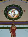 Stained Glass in the Church


See also
External links
- Artigues on Lion1906
- Artigues on Google Maps
- Artigues on Géoportail, National Geographic Institute (IGN) website Template:Fr icon
- Arugues on the 1750 Cassini Map
- Artigues on the INSEE website Template:Fr icon
- INSEE Template:Fr icon
Notes and references
Notes
- ^ At the beginning of the 21st century, the methods of identification have been modified by Law No. 2002-276 of 27 February 2002, the so-called "law of local democracy" and in particular Title V "census operations" allows, after a transitional period running from 2004 to 2008, the annual publication of the legal population of the different French administrative districts. For communes with a population greater than 10,000 inhabitants, a sample survey is conducted annually, the entire territory of these communes is taken into account at the end of the period of five years. The first "legal population" after 1999 under this new law came into force on 1 January 2009 and was based on the census of 2006.