
Bassett, Southampton
| Bassett | |
|---|---|
_-_geograph.org.uk_-_1027183.jpg) Bassett Avenue | |
| Area | 4.48 km2 (1.73 sq mi) |
| Population | 13,139 [1] |
| • Density | 2,933/km2 (7,600/sq mi) |
| Unitary authority | |
| Ceremonial county | |
| Region | |
| Country | England |
| Sovereign state | United Kingdom |
| Post town | SOUTHAMPTON |
| Postcode district | SO16 |
| Dialling code | 023 |
| Police | Hampshire and Isle of Wight |
| Fire | Hampshire and Isle of Wight |
| Ambulance | South Central |
| UK Parliament | |
Bassett is a suburb and electoral ward of the City of Southampton, England. The suburb lies to the north of the city centre and is largely residential, including the University of Southampton's Glen Eyre Halls of residence complex, which houses around 2,100 students. Bassett gives its name to part of the A33 arterial road which links the city centre to the M3, described by Pevsner & Lloyd as "part of the splendid tree-lined route into Southampton from Winchester, London and the north".[2] The highest point in the City of Southampton (its "county top") lies on Bassett Avenue at a height of 82 metres (269 ft) above sea level.
Bassett Ward comprises Bassett, Bassett Green and Lordswood. It had a population of 13,139 as of the 2001 Census.[1]
History
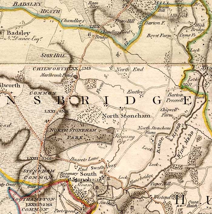
A family named 'Basset' is known to have lived in South Stoneham in the 15th century, and the place name may be from their name.[3] The area broadly occupied by Bassett today was known as Stoneham Common, shown on the 1791 map by Thomas Milne on which 'Bassets Lane' also appears (without any associated village).[4] The village of Bassett appears on a 1810 map, located roughly where Bassett Green Village is today.[5] In the late 18th century it grew as a retreat for rich people outside (and away from civic responsibilities in) the borough of Southampton. By the time of the Ordnance Survey of 1897, Basset had been renamed Bassett Green (with a double 't'), and a more westerly area (west of Bassett Wood) was identified as Bassett.[6]
By the late 19th century, Bassett consisted of many substantial villas occupied by the middle classes. Despite having the appearance of a well-to-do district on the edge of the town, Revd. Elliott Kenworthy-Browne (rector of North Stoneham from 1886 to 1912) observed that three-quarters of the population of 800 were poor, chiefly mechanics and labourers.[7]
In 1920 the boundaries of Southampton were extended to include Bassett, along with Bitterne, Sholing, Woolston, Weston, Peartree and Swaythling.[8]
Parish

Bassett was originally part of the parish of North Stoneham, which can be traced back to the early 9th century when it was known as "Stonam Abbatis" or "Abbots Stoneham", and was attached to Hyde Abbey at Winchester.[9] After the dissolution of the monasteries in the 1540s, the manor was acquired by Thomas Wriothesley, Earl of Southampton. In 1599, the Wriothesley family sold the estate to Sir Thomas Fleming.[10]
With the growth of Bassett came the construction of a second church within the parish, located on Bassett Avenue. The foundation stone for the new church was laid in 1897 and St Michael and All Angels Church is now a "Grade II listed building".[11] The parish has since been renamed "North Stoneham and Bassett", and encompasses the whole of Bassett, the portion of Bassett Green north of Bassett Green Road, North Stoneham, and the portion of Chilworth within the M3/M27 triangle. The parish also covers Southampton Airport.[12]
All Saints Church on Winchester Road was inaugurated in 1970 to serve the needs of the western edge of the parish.[13]
Education
Unusually, Bassett does not have any infant, junior or primary schools within the area, the closest being located in Lordswood, Highfield and Bassett Green. Cantell School is located within Bassett, serving a large catchment within the central area of Southampton. The school is a comprehensive secondary school with a specialism in Mathematics and Information and Communication Technology, and is thus officially titled Cantell Mathematics and Computing College. The school has also been largely rebuilt funded through the Private Finance Initiative.[14]
The University of Southampton's distinctive Boldrewood Campus buildings are situated just off Bassett Avenue. The campus housed the Biomedical Sciences Centre until its closure in 2010. It has now been demolished to make way for new buildings. The firm Grimshaw Architects has produced designs for the new campus, which will house a joint centre for the University of Southampton and Lloyd's Register. The first phase of construction is due to be completed in 2014.[15]
Sports Facilities

Bassett is home to several of Southampton's main sports facilities:
Southampton Sports Centre
The centre is a 150 acre site with facilities for football, netball, cricket, cyclo cross, cross country, athletics, tennis, bowling, volleyball, crazy golf, putting, and hockey. The area has been used for the Millennium Youth Games, National Cyclocross Championships and to hold outdoor classical concerts.[16]
Southampton Snowsports Centre
The centre has three dry ski slopes: a main slope of 110 metres; a second slope of 90 metres and a nursery slope of 30 metres long. All slopes are fully floodlit.
Southampton City Golf Course
Originally known as Southampton Municipal Golf Course or 'Muni', the course is a 27-hole venue set in woodland. The course was designed by five times British Open Champion J. H. Taylor, and was completed in 1935. It recently celebrated its 75th Anniversary in 2010.
Red Lodge Community Pool
Bassett has its own 20-metre swimming pool. Red Lodge Community Pool was threatened with demolition in 1999 and is now run by a charitable trust. The pool offers swimming lessons, community group bookings and public sessions.[17]
Local Links
Old Bassett Residents Association
North West Bassett Residents Association
North East Bassett Residents Association
References
- ^ a b "Bassett(Ward) – Key Figures for 2001 Census: Key Statistics". Office for National Statistics. 2001. Retrieved 28 June 2008.
- ^ Coles, R.J. (1981). Southampton's Historic Buildings. City of Southampton Society. p. 10.
- ^ Coates: "Old Hampshire Gazetteer" Retrieved 20 September 2011
- ^ Milne: "Manor of North Stoneham" Retrieved 1 October 2011
- ^ Ordnance Survey, 1810
- ^ Ordnance Survey, 1897
- ^ Mann, John Edgar (2002). Book of the Stonehams. Tiverton: Halsgrove. pp. 54–55. ISBN 1-84114-213-1.
- ^ Lambert: "A brief history of Southampton"
- ^ "North Stoneham". Hampshire Villages. Southern Life. Retrieved 25 November 2009.
- ^ "North Stoneham Park: Introduction". North Stoneham Park. 2008–2009. Archived from the original on 5 December 2009. Retrieved 25 November 2009.
{{cite web}}: Unknown parameter|deadurl=ignored (|url-status=suggested) (help) - ^ "English Heritage listing for the church". Images of England. English Heritage. 2007. Retrieved 30 November 2009.
- ^ The Church of England, Parish of North Stoneham & Bassett
- ^ "Our Churches". The Parish of North Stoneham and Bassett, Southampton. Retrieved 1 October 2011.
- ^ Southampton Schools
- ^ "Grimshaw to establish much-needed cornerpiece to Southampton University's Boldrewood Campus" Retrieved 20 September 2011
- ^ Southampton City Council"
- ^ Red Lodge Community Pool"
Places adjacent to Bassett, Southampton | |
|---|---|
Areas and suburbs of Southampton | |||||||
|---|---|---|---|---|---|---|---|
| |||||||
| Southampton Itchen |
| ||||||
| Southampton Test | |||||||
| Romsey and Southampton North | |||||||
| |||||||
