
Boeschepe
Boeschepe | |
|---|---|
 | |
_Nord-France.svg) Coat of arms | |
Location of Boeschepe  | |
| Country | France |
| Region | Hauts-de-France |
| Department | Nord |
| Arrondissement | Dunkerque |
| Canton | Steenvoorde |
| Intercommunality | Monts de Flandres |
| Government | |
| • Mayor (2008–2014) | Pierre Bourgeois |
| Area 1 | 13.59 km2 (5.25 sq mi) |
| Population (2009) | 2,202 |
| • Density | 160/km2 (420/sq mi) |
| Time zone | UTC+01:00 (CET) |
| • Summer (DST) | UTC+02:00 (CEST) |
| INSEE/Postal code | 59086 /59299 |
| Elevation | 28–153 m (92–502 ft) (avg. 74 m or 243 ft) |
| 1 French Land Register data, which excludes lakes, ponds, glaciers > 1 km2 (0.386 sq mi or 247 acres) and river estuaries. | |
Boeschepe is a commune in the Nord department in northern France, next to the Belgian border.
Population
| Year | Pop. | ±% |
|---|---|---|
| 1793 | 1,758 | — |
| 1800 | 1,473 | −16.2% |
| 1806 | 1,692 | +14.9% |
| 1821 | 1,862 | +10.0% |
| 1831 | 1,935 | +3.9% |
| 1836 | 1,975 | +2.1% |
| 1841 | 1,938 | −1.9% |
| 1846 | 1,953 | +0.8% |
| 1851 | 1,985 | +1.6% |
| 1856 | 1,954 | −1.6% |
| 1861 | 2,011 | +2.9% |
| 1866 | 2,103 | +4.6% |
| 1872 | 2,201 | +4.7% |
| 1876 | 2,241 | +1.8% |
| 1881 | 2,175 | −2.9% |
| 1886 | 2,222 | +2.2% |
| 1891 | 2,234 | +0.5% |
| 1896 | 2,208 | −1.2% |
| 1901 | 2,184 | −1.1% |
| 1906 | 2,284 | +4.6% |
| 1911 | 2,180 | −4.6% |
| 1921 | 2,064 | −5.3% |
| 1926 | 2,093 | +1.4% |
| 1931 | 1,969 | −5.9% |
| 1936 | 2,058 | +4.5% |
| 1946 | 2,111 | +2.6% |
| 1954 | 2,089 | −1.0% |
| 1962 | 2,085 | −0.2% |
| 1968 | 2,015 | −3.4% |
| 1975 | 1,883 | −6.6% |
| 1982 | 1,747 | −7.2% |
| 1990 | 1,906 | +9.1% |
| 1999 | 2,012 | +5.6% |
| 2006 | 2,177 | +8.2% |
| 2009 | 2,202 | +1.1% |
Heraldry
|
The arms of Boeschepe are blazoned : Or, 3 chevrons sable. (Bersillies, Boeschepe, Boussières-sur-Sambre, Colleret, Cousolre, Flaumont-Waudrechies, Hautmont, Limont-Fontaine, Lompret, Masny, Neuville-en-Avesnois and Saint-Rémy-du-Nord use the same arms.)
|
See also
References
-
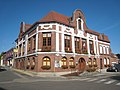 Town hall
 -
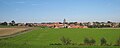 View of Boeschepe from the south
 -
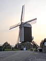 The Ondankmeulen (unthankfullness windmill)


Wikimedia Commons has media related to Boeschepe.
This Nord geographical article is a stub. You can help Wikipedia by expanding it. |