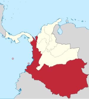
Cauca State
Appearance


Cauca State was one of the states of Colombia.
Today the area of the former state makes up most of modern day west and southern Colombia, with some portion of its vast territories acquired by present day Peru, Brazil, Ecuador and Venezuela.
Naming
- 1857-06-15 created as Estado Federal del Cauca (Federal State of Cauca).
- 1858 recognized as Estado de la Federación in the 1858 constitution of the Granadine Confederation,[1]
- 1863 named Estado Soberano del Cauca (Sovereign State of Cauca) in the 1863 constitution of the United States of Colombia.[2]
Known as "Gran Cauca", because it was the largest [3] and richest[4] of the Union.
Subdivisions
In the 15 June 1857 law, the state was divided into the following provinces [5]
- Barbacoas Province (capital Barbacoas).
- Buenaventura Province (capital Cali).
- Chocó Province (capital Quibdó).
- Cauca Province (capital Buga).
- Pasto Province (capital San Juan de Pasto).
- Popayán Province (capital Popayán).
- Túquerres Province (capital Ipiales).
- Caquetá Territory (capital Mocoa).
In 1858, the setup was changed, Barbacoas and Túquerres were added to Pasto:[5]
- Buenaventura Province (capital Cali).
- Chocó Province (capital Quibdó).
- Cauca Province (capital Buga).
- Pasto Province (capital San Juan de Pasto).
- Popayán Province (capital Popayán).
- Caquetá Territory (capital Mocoa).
In 1874, the provinces had been changed into municipalities and the number increased to 16:[5]
- Atrato (capital Quibdó).
- Barbacoas (capital Barbacoas).
- Buenaventura (capital Buenaventura).
- Buga (capital Buga).
- Caldas (capital Almaguer).
- Cali (capital Cali).
- Obando (capital Ipiales).
- Palmira (capital Palmira).
- Pasto (capital San Juan de Pasto).
- Popayán (capital Popayán).
- Quindío (capital Cartago).
- Santander (capital Santander de Quilichao).
- San Juan (capital Nóvita).
- Toro (capital Toro).
- Tulúa (capital Tuluá).
- Túquerres (capital Túquerres).
References
- ^ Cervantes Virtual: Constitución de la Confederación Granadina de 1858[permanent dead link]
- ^ Cervantes Virtual: Constitución política de los Estados Unidos de Colombia de 1863[permanent dead link]
- ^ Colombiestad: Estadística de Colombia 1876
- ^ Biblioteca Luis Ángel Arango: División territorial de Colombia
- ^ a b c Geografía Física y Política de la Confederación Granadina: Estado del Cauca, Obra dirigida por el General Agustín Codazzi, 2003
See also
2°27′00″N 76°37′00″W / 2.45°N 76.6167°W
