Chamula
This article needs additional citations for verification. (November 2009) |
- For the wasp genus, see Chamula (wasp)
Chamula | |
|---|---|
Municipality | |
 | |
| Country | |
| State | Chiapas |
| Population (2010) | |
| • Total | 76,941 |
San Juan Chamula is a municipio (municipality) and township in the Mexican state of Chiapas. It is situated some 10 km (6.2 mi) from San Cristóbal de las Casas.[1] As of 2010, the municipality had a total population of 76,941.[2] Virtually the entire population of the municipality is indigenous and speaks an indigenous language. In 2010, the census reported that 99.5% of the population age 3 years or older speaks an indigenous language. [3] The Tzotzil ethnic group and language dominate the municipality.
Situation
Chamula is located in the Chiapas highlands, at an altitude of 2,200 meters (7,200 feet); it is inhabited by the indigenous Tzotzil Maya people, whose Tzotzil language is one of the Mayan languages.
The town enjoys unique autonomous status within Mexico. No outside police or military are allowed in the village. Chamulas have their own police force. One of the best ethnographic descriptions of Chamula in English is Chamulas in the World of the Sun by Gary H. Gossen.
Demographics
As of 2010, the town of Chamula had a population of 3,329.[2] Other than the town of Chamula, the municipality had 149 localities, the largest of which (with 2010 populations in parentheses) were: Cruztón (1,756), Yaltem (1,664), Chicumtantic (1,599), Nichnamtic (1,496), Muquén (1,480), Majomut (1,450), Saclamantón (1,348), Catishtic (1,319), Romerillo (1,310), Cuchulumtic (1,275), Narváez (1,207), Bautista Chico (1,173), Las Ollas (1,165), Macvilho (1,142), Tentic (1,121), Arvenza Uno (1,107), Pugchén Mumuntic (1,046), and Tzontehuitz (1,004), classified as rural.[2]
Sights

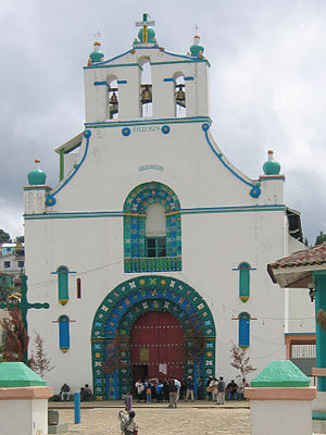
The church of San Juan, in the municipal cabecera (headtown), is filled with colorful candles, and smoke from burning copal resin incense, commonly used throughout southern Mexico. Along the walls of the church, as in many Catholic churches, are dressed-up wooden statues of saints in large wooden cases, many wearing mirrors to deflect evil.[citation needed] The local form of Catholicism is a blend of pre-conquest Maya customs, Spanish Catholic traditions, and subsequent innovations.
There are no pews in the church, and the floor area is completely covered in a carpet of green pine boughs. Curanderos (medicine men) diagnose medical, psychological or ‘evil-eye’ afflictions and prescribe remedies such as candles of specific colors and sizes, specific flower petals or feathers, or - in a dire situation - a live chicken. The specified remedies are brought to a healing ceremony. Chamula families kneel on the floor of the church with sacrificial items, stick candles to the floor with melted wax, drink ceremonial cups of Posh, artisanal sugar-cane-based liquor, and chant prayers in an archaic dialect of Tzotzil.
Photography in the town is very difficult as parents will hide their children or they themselves will turn away as soon as they spot a camera. Photography within the church is strictly prohibited as is photographing the Christmas procession to the church. They can throw you out of town if you attempt to violate this rule.
The main agricultural products are corn, beans, potatoes, and cabbage.[citation needed]
Women often make traditional clothing, blankets, and souvenirs that include Zapatista-related items, such as pens with a clay figure on top in the figure of Subcomandante Marcos or Comandante Tacho.
References
- ^ Noble, John (2006). Mexico. Vol. 10 (10 ed.). Lonely Planet guidebooks. p. 826. ISBN 1-74059-744-3.
- ^ a b c "Chamula". Catálogo de Localidades. Secretaría de Desarrollo Social (SEDESOL). Retrieved 23 April 2014.
- ^ https://www.scribd.com/doc/51752151/Principales-resultados-del-Censo-2010-Chiapas?q=hablantes%2Blengua%2Bindigena%2Bchiapas%2B2010%26espv%3D2%26biw%3D1366%26bih%3D643
External links
- Report of religious conflicts between Catholics and Evangelicals in Chamula in the late nineties
- The Elliott's 'Remedy' Website
- Template:Es icon Video from the town square during a festival, including a conversation with two young Chamulas (17 September 2007).

