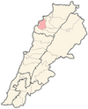
Darchmezzine
Appearance
Darchmezzine | |
|---|---|
Village | |
| Coordinates: 34°17′24.0″N 35°47′02.4″E / 34.290000°N 35.784000°E | |
| Country | |
| Governorate | North Governorate |
| District | Koura District |
| Area | |
• Total | 343 ha (848 acres) |
| Elevation | 390 m (1,280 ft) |
| Population | |
• Total | 325 |
| Time zone | UTC+2 (EET) |
| • Summer (DST) | UTC+3 (EEST) |
| Area code | +961 |
Darchmezzine, Dar Chmizzine, (Arabic: دارشمزين) is a Lebanese local authority which is located in Koura District, an administrative division of North Lebanon Governorate. The municipality is member of the Federation of Koura Municipalities.[1] In 1953, Darchmezzine had a population of 133 living in 30 households.[2]
Geography
[edit]Darchmezzine is located south of the town of Amioun and approximately 80 kilometers away north-northeast of Beirut. Situated between the sea and the mountains, Darchmezzine is characterized by a quiet rural atmosphere, a distinctive scenic view and a moderate Mediterranean climate. The area is rich of olive trees and orchards.
References
[edit]- ^ Localiban. "Federation of Koura Municipalities - Localiban". www.localiban.org. Retrieved 2019-12-31.
- ^ Sawaya, Salah Michel (March 1953). Household Income and Expenditure in Al-Kura, Lebanon (PDF). Scholarworks (M.A.). Beirut, Lebanon: Economics Dept., American University of Beirut, Lebanon. hdl:10938/3411. Archived from the original (PDF) on 24 March 2023. Retrieved 2023-03-24.
External links
[edit]- Dar Chmizzine, Localiban
34°17′02″N 35°47′00″E / 34.2840°N 35.7834°E


