Jump to content

Del Bonita, Montana

Coordinates: 48°59′53″N 112°47′17″W / 48.99806°N 112.78806°W / 48.99806; -112.78806
From Wikipedia, the free encyclopedia

This is an old revision of this page, as edited by Alaney2k (talk | contribs) at 04:40, 17 May 2016 (top: update wlinks, replaced: Canada – United States borderCanada–United States border using AWB). The present address (URL) is a permanent link to this revision, which may differ significantly from the current revision.

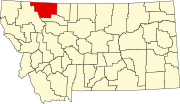
Del Bonita, also known as Port of Del Bonita, is a unincorporated community in Glacier County, Montana, United States. Its elevation is 4,363 feet (1,330 m) and it is located at 48°59′53″N 112°47′17″W / 48.99806°N 112.78806°W / 48.99806; -112.78806.[1] It is on the Canada–United States border, south of Del Bonita, Alberta.

Climate

This climatic region is typified by large seasonal temperature differences, with warm to hot (and often humid) summers and cold (sometimes severely cold) winters. According to the Köppen Climate Classification system, Del Bonita has a humid continental climate, abbreviated "Dfb" on climate maps.[2]

References

  1. ^ "Del Bonita, Montana". Geographic Names Information System. United States Geological Survey, United States Department of the Interior. Retrieved 2009-07-19.
  2. ^ Climate Summary for Del Bonita, Montana