Dimovo Municipality
Appearance
Dimovo Municipality
Община Димово | |
|---|---|
Municipality | |
 E78 road in Dimovo | |
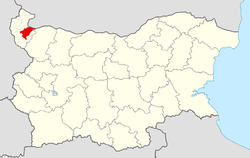
 Dimovo Municipality within Bulgaria and Vidin Province. | |
| Coordinates: 43°43′N 22°46′E / 43.717°N 22.767°E | |
| Country | |
| Province (Oblast) | Vidin |
| Admin. centre (Obshtinski tsentar) | Dimovo |
| Area | |
• Total | 402.87 km2 (155.55 sq mi) |
| Population (December 2009)[1] | |
• Total | 7,175 |
| Time zone | UTC+2 (EET) |
| • Summer (DST) | UTC+3 (EEST) |
Dimovo Municipality (Template:Lang-bg) is a municipality (obshtina) in Vidin Province, Northwestern Bulgaria, located along the right bank of Danube river in the Danubian Plain. It is named after its administrative centre - the town of Dimovo.
The municipality embraces a territory of 402.87 km² with a population of 7,175 inhabitants, as of December 2009.[1]
The main road E79 (I-1) crosses the area, connecting the province centre of Vidin with the city of Montana and respectively with the western operating part of Hemus motorway.
Settlements
Template:Dimovo Municipality Labelled Map
Dimovo Municipality includes the following 23 places (towns are shown in bold):
| Town/Village | Cyrillic | Population[2][3][4] (December 2009) |
|---|---|---|
| Dimovo | Димово | 1,211 |
| Archar | Арчар | 2,603 |
| Bela | Бела | 120 |
| Dalgo Pole | Дълго поле | 27 |
| Darzhanitsa | Държаница | 107 |
| Gara Oreshets | Гара Орешец | 819 |
| Izvor | Извор | 311 |
| Karbintsi | Карбинци | 241 |
| Kladorub | Кладоруб | 44 |
| Kostichovtsi | Костичовци | 114 |
| Lagoshevtsi | Лагошевци | 89 |
| Mali Drenovets | Мали Дреновец | 83 |
| Medovnitsa | Медовница | 327 |
| Oreshets | Орешец | 15 |
| Ostrokaptsi | Острокапци | 98 |
| Septemvriytsi | Септемврийци | 251 |
| Skomlya | Скомля | 43 |
| Shipot | Шипот | 76 |
| Vladichentsi | Владиченци | 80 |
| Vodnyantsi | Воднянци | 279 |
| Varbovchets | Върбовчец | 94 |
| Yanyovets | Яньовец | 33 |
| Yarlovitsa | Ярловица | 110 |
| Total | 7,175 |
Demography
The following table shows the change of the population during the last four decades.
| Dimovo Municipality | ||||||||
|---|---|---|---|---|---|---|---|---|
| Year | 1975 | 1985 | 1992 | 2001 | 2005 | 2007 | 2009 | 2011 |
| Population | 9,520 | 7,500 | 10,608 | 8,783 | 8,065 | 7,531 | 7,175 | 6,514 |
| Sources: Census 2001,[5] Census 2011,[6] „pop-stat.mashke.org“,[7] | ||||||||
See also
References
- ^ a b Template:En icon Bulgarian National Statistical Institute - Bulgarian provinces and municipalities in 2009 Archived November 13, 2010, at the Wayback Machine
- ^ Template:En icon Bulgarian National Statistical Institute - Bulgarian towns in 2009 Archived November 13, 2010, at the Wayback Machine
- ^ Template:En icon Bulgarian National Statistical Institute - Bulgarian villages under 1000 inhabitants - December 2009
- ^ Template:En icon Bulgarian National Statistical Institute - Bulgarian Settlements 1000-5000 inhabitants - December 2009
- ^ Template:En iconNational Statistical Institute - Census 2001
- ^ „pop-stat.mashke.org“
- ^ "Population of Bulgarian divisions". Pop-stat.mashke.org. 2011-02-01. Retrieved 2012-03-28.
