Dolus-d'Oléron
Appearance
Dolus-d'Oléron | |
|---|---|
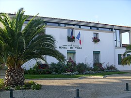
 The town hall in Dolus-d'Oléron | |
| Coordinates: 45°54′43″N 1°15′35″W / 45.9119°N 1.2597°W | |
| Country | France |
| Region | Nouvelle-Aquitaine |
| Department | Charente-Maritime |
| Arrondissement | Rochefort |
| Canton | Île d'Oléron |
| Intercommunality | Île-d'Oléron |
| Government | |
| • Mayor (2022–2026) | Thibault Brechkoff[1] |
| Area 1 | 29.02 km2 (11.20 sq mi) |
| Population (2021)[2] | 3,155 |
| • Density | 110/km2 (280/sq mi) |
| Time zone | UTC+01:00 (CET) |
| • Summer (DST) | UTC+02:00 (CEST) |
| INSEE/Postal code | 17140 /17550 |
| Elevation | 0–20 m (0–66 ft) |
| 1 French Land Register data, which excludes lakes, ponds, glaciers > 1 km2 (0.386 sq mi or 247 acres) and river estuaries. | |
Dolus-d'Oléron (French pronunciation: [dɔlys dɔleʁɔ̃], literally Dolus of Oléron) is a commune on the Isle of Oléron in the Charente-Maritime department, southwestern France. The area is mostly residential, with a village-style main street with a church and small complex of amenities including a large supermarket, petrol station, DIY shop and some other retail. At the coast is Vert Bois woods and Vert Bois beach.
Population
[edit]| Year | Pop. | ±% p.a. |
|---|---|---|
| 1968 | 1,786 | — |
| 1975 | 2,006 | +1.67% |
| 1982 | 2,145 | +0.96% |
| 1990 | 2,440 | +1.62% |
| 1999 | 2,723 | +1.23% |
| 2007 | 3,156 | +1.86% |
| 2012 | 3,207 | +0.32% |
| 2017 | 3,229 | +0.14% |
| Source: INSEE[3] | ||
See also
[edit]References
[edit]- ^ "Répertoire national des élus: les maires" (in French). data.gouv.fr, Plateforme ouverte des données publiques françaises. 16 December 2022.
- ^ "Populations légales 2021" (in French). The National Institute of Statistics and Economic Studies. 28 December 2023.
- ^ Population en historique depuis 1968, INSEE
External links
[edit] Media related to Dolus-d'Oléron at Wikimedia Commons


