
Göreme
You can help expand this article with text translated from the corresponding article in Turkish. (July 2009) Click [show] for important translation instructions.
|
| UNESCO World Heritage Site | |
|---|---|
 Göreme town and valley | |
| Location | Turkey |
| Criteria | Natural (Volcanic Rock): i, iii, v, vii |
| Reference | 357 |
| Inscription | 1985 (9th Session) |
Göreme (pronounced [ˈɟøɾeme]; Ancient Greek: Κόραμα, Kòrama), located among the "fairy chimney" rock formations, is a town in Cappadocia, a historical region of Turkey. It is in the Nevşehir Province in Central Anatolia and has a population of around 2,000 people.[1]
Former names of the town have been Korama, Matiana, Maccan or Machan, and Avcilar.[2] When Göreme Valley nearby was designated an important tourist destination, a "center" for all tourism in Cappadocia, the name of the town was changed to Göreme for practical reasons.
The Göreme National Park (Göreme Tarihî Millî Parkı in Turkish) was added to the UNESCO World Heritage List in 1985.[1]
The time that the Göreme was first settled is unclear, but it could date back as the Hittite era, between 1800 and 1200 B.C. The location was central between rivaling empires, such as the Greeks and Persians, leading the natives to tunnel into the rock to escape the political turmoil. During the Roman era, the area became home to Christians retreating from Rome.[3] Christianity prevailed as the primary religion in the region, which is evident from many rock churches that can still be seen today.
Among Göreme's historically important sites are Ortahane, Durmus Kadir, Yusuf Koc and Bezirhane churches, in addition to the richly decorated Tokali Kilise, the Apple Church, and a number of homes and pigeon houses carved straight into the rock formations in the town.

Gallery
-
 Göreme cafe owner making flatbread
 -
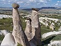 Fairy Chimney Rock Formations.
 -
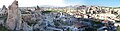 View of Göreme
 -
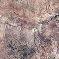 Goreme national park as seen from space.


See also
References
- ^ a b Lynch, Paul; McIntosh, Alison J.; Tucker, Hazel (2 June 2009). Commercial Homes in Tourism: An International Perspective. Routledge. ISBN 9781134030286.
- ^ "Goreme.org - Goreme". goreme.org. Retrieved 30 August 2015.
- ^ Society, National Geographic. "Cappadocia -- World Heritage Site -- National Geographic". Retrieved 30 August 2015.
External links
 Goreme travel guide from Wikivoyage
- Durmus Kadir church