
Gazzo Veronese
Gazzo Veronese | |
|---|---|
| Comune di Gazzo Veronese | |
 Coat of arms | |
Location of Gazzo Veronese  | |
| Country | Italy |
| Region | Veneto |
| Province | Verona (VR) |
| Frazioni | Gazzo, Maccacari, Correzzo, Paglia, San Pietro in Valle, Pradelle, Roncanova |
| Government | |
| • Mayor | Ugo Vecchini (Lega Nord) |
| Area | |
| • Total | 56.7 km2 (21.9 sq mi) |
| Elevation | 16 m (52 ft) |
| Population (1 June 2007)[2] | |
| • Total | 5,581 |
| • Density | 98/km2 (250/sq mi) |
| Demonym | Gazzesi |
| Time zone | UTC+1 (CET) |
| • Summer (DST) | UTC+2 (CEST) |
| Postal code | 37060 |
| Dialing code | 0442 |
| Saint day | 5 August |
| Website | Official website |
Gazzo Veronese is a comune (municipality) in the Province of Verona in the Italian region Veneto, located about 100 km (62 mi) southwest of Venice and about 30 km (19 mi) south of Verona.
Gazzo Veronese borders the following municipalities: Casaleone, Nogara, Ostiglia, Sanguinetto, Serravalle a Po, Sorgà, Sustinente and Villimpenta.
The economy is mostly based on agriculture.
History
Gazzo's area was inhabited since the 4th millennium BC, but the modern settlement has Lombard origin. Its name derives in fact from the Lombard gahagi, meaning "wood". In Roman times it should be already populated, but the inhabitants fled with the fall of the Western Roman Empire. In the 9th century Benedictine monks of the Veronese church of Santa Maria in Organo dried the area. The fief was wold to Federico della Scala in 1307.
The current comune was created in 1929 by the merger of Gazzo and Correzzo, the municipal set being moved to the frazione of Roncanova in the occasion.
Main sights
Main sights include
- the Romanesque 12th-century church of Santa Maria Maggiore, on the Tartaro river.
- The ruins of Gazzo Castle.
- Roman Tower (4th century AD).
- The church (Ceson) of San Pietro in Valle, at Pradelle.
- Church of San Prosdocimo, dating from the 15th century, also at Pradelle.
References
- ^ "Superficie di Comuni Province e Regioni italiane al 9 ottobre 2011". Italian National Institute of Statistics. Retrieved 16 March 2019.
- ^ All demographics and other statistics: Italian statistical institute Istat.
External links
Views of Oasi WWF della Palude del Busatello (Gazzo Veronese Italy)
-
 View of Carex Oasi WWF Palude Busatello at Gazzo Veronese Italy
 -

-

-
 Carex BirdWatcher observation hut Oasi WWF Palude Busatello at Gazzo Veronese Italy
 -
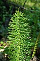 Equisetum Oasi WWF Palude Busatello at Gazzo Veronese Italy
 -
 Carex Oasi WWF Palude Busatello at Gazzo Veronese Italy
 -
 Carex Oasi WWF Palude Busatello at Gazzo Veronese Italy
 -
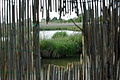
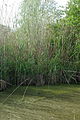
 Phragmites australis Oasi WWF Palude Busatello at Gazzo Veronese Italy
 -
 View of Lemna minor Oasi WWF Palude Busatello at Gazzo Veronese Italy
 -
 Salix Oasi WWF Palude Busatello at Gazzo Veronese Italy
 -
 Populus alba Oasi WWF Palude Busatello at Gazzo Veronese Italy
 -
 View of Salix Oasi WWF Palude Busatello at Gazzo Veronese Italy
_Giornata_delle_Oasi_2012-04-25_photo_WWF_Verona_Paolo_Villa_9095.JPG)
_Giornata_delle_Oasi_2012-04-25_photo_WWF_Verona_Paolo_Villa_9130.JPG)
_Giornata_delle_Oasi_2012-04-25_photo_WWF_Verona_Paolo_Villa_9114.JPG)
_Giornata_delle_Oasi_2012-04-25_photo_WWF_Verona_Paolo_Villa_9119.JPG)
_Giornata_delle_Oasi_2012-04-25_photo_WWF_Verona_Paolo_Villa_9042.JPG)
_Giornata_delle_Oasi_2012-04-25_photo_WWF_Verona_Paolo_Villa_9082.JPG)
_Giornata_delle_Oasi_2012-04-25_photo_WWF_Verona_Paolo_Villa_9135.JPG)
_Giornata_delle_Oasi_2012-04-25_photo_WWF_Verona_Paolo_Villa_9085.JPG)
_Giornata_delle_Oasi_2012-04-25_photo_WWF_Verona_Paolo_Villa_9124.JPG)
_Giornata_delle_Oasi_2012-04-25_photo_WWF_Verona_Paolo_Villa_9098.JPG)
_Giornata_delle_Oasi_2012-04-25_photo_WWF_Verona_Paolo_Villa_9102.JPG)
_Giornata_delle_Oasi_2012-04-25_photo_WWF_Verona_Paolo_Villa_9026.JPG)