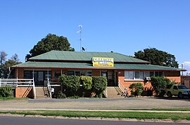
Grantham, Queensland
| Grantham Queensland | |
|---|---|
 Grantham Hotel, located in Anzac Ave | |
| Population | 492 (2011 census)[1] |
| Postcode(s) | 4347 |
| Elevation | 109 m (358 ft) |
| Location | |
| LGA(s) | Lockyer Valley Region |
| County | Cavendish |
| Parish | Lockyer |
| State electorate(s) | Lockyer |
| Federal division(s) | Wright |
Grantham is a town in the Lockyer Valley region of Queensland, Australia. The town is located 100 kilometres (62 mi) west of the state capital, Brisbane. At the 2011 census, Grantham and the surrounding area had a population of 492.[1]
History
The area was first settled in 1841, by George Mocatta.[2] In 1866 a railway siding from the main Toowoomba line was opened which assisted in the development of a small settlement. It wasn't until the mid-1879s that a railway station was built.[2] A butter factory was established in 1907. The building was replaced in 1926 by a brick building which operated until 1971.[2]
Grantham Post Office opened on 1 January 1890 (a receiving office had been open from 1876).[3]
2011 flash floods
On 10 January 2011, Grantham was severely damaged in a huge flash flood. Twelve people lost their lives and a large number of houses and other buildings were destroyed.[4]
Following the floods, Grantham received visits by politicians including Queensland Premier Anna Bligh on numerous occasions. Australia's Governor-General Quentin Bryce also visited the town.[5]
In May 2011, it was announced that the town would be moved to higher ground to prevent future damaging floods.[6] A 935-acre site was purchased so that landholders could be provided a voluntary swap of equivalent-sized blocks. The new site is situated on a hill overlooking Grantham and has permission from the state government to bypass the normal development approval process.[7] Resident of nearby Murphys Creek, Postmans Ridge, Withcott and Helidon have been included in the fast-tracked plan.
References
- ^ a b Australian Bureau of Statistics (31 October 2012). "2011 Community Profiles: Grantham (SSC) (State Suburb)". 2011 Census of Population and Housing. Retrieved 7 April 2013.
- ^ a b c Environmental Protection Agency (Queensland) (2000). Heritage Trails of the Great South East. State of Queensland. p. 61. ISBN 0-7345-1008-X.
- ^ Premier Postal History. "Post Office List". Premier Postal Auctions. Retrieved 10 May 2014.
- ^ Walter Sofronoff (October 2015). "Grantham Floods Commission of Inquiry" (PDF).
- ^ Tom Threadingham (24 May 2011). "Power and passion". Gatton, Lockyer and Brisbane Valley Star. APN News & Media Ltd. Retrieved 17 June 2011.
- ^ Georgia Waters (5 May 2011). "Flooded Queensland town to be relocated". Brisbane Times. Fairfax Media. Retrieved 17 June 2011.
- ^ Matt Wordsworth (8 June 2011). "Flood-ravaged Grantham moves to higher ground". ABC News. Australian Broadcasting Corporation. Retrieved 17 June 2011.
External links
- Grantham is a town left in tatters Video of flood damage
- Grantham Flood Support A fundraiser helping with Grantham relief
