Heward, Saskatchewan
Heward | |
|---|---|
| Village of Heward | |
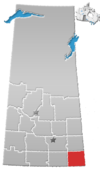
Location of Heward in Saskatchewan | |
| Coordinates: 49°44′13″N 103°08′46″W / 49.737°N 103.146°W | |
| Country | |
| Province | |
| Region | Saskatchewan |
| Census division | 1 |
| Rural Municipality | Tecumseh No. 65 |
| Government | |
| • Governing body | Heward Village Council |
| • Mayor | Doug Trowell |
| • Administrator | Zandra Slater |
| • MP | Robert Kitchen |
| • MLA | Dan D'Autremont |
| Area | |
| • Total | 0.99 km2 (0.38 sq mi) |
| Population (2016) | |
| • Total | 44 |
| • Density | 44.5/km2 (115/sq mi) |
| Time zone | UTC-6 (CST) |
| Postal code | S0G 2G0 |
| Area code | 306 |
| Highways | |
| [1][2][3][4] | |
Heward is a Village within the Rural Municipality of Tecumseh No. 65, in the province of Saskatchewan, Canada. The village is located along highway 33 in southeastern Saskatchewan. Even though it has under 50 people it still maintains a post office, rink, and hall that all service the farming community. In 1977 Prairie Trails and Tales: Heward Saskatchewan 1900-1976 was written by Muriel Dempsey. The book goes into great detail about the families that lived in the community.
History
Bryce Dickey who was born in Heward in 1908 wrote a very extensive history of the village which is published in the summer 2007 issue of Folklore magazine. He describes how "Reverend Pike, an Englishman and a bachelor decided to build a new church and it was to be the same design and construction as one in England that had been lost to the sea due to coastal erosion. The chimes and font were from this church and were installed in the Heward church. When the church was finally closed, the chimes and font were sent to a church in Regina.[5]
Demographics
| 2016 | 2011 | |
|---|---|---|
| Population | 44 (10.0% from 2011) | 40 (100.0% from 2006) |
| Land area | 0.99 km2 (0.38 sq mi) | 0.99 km2 (0.38 sq mi) |
| Population density | 44.5/km2 (115/sq mi) | 40.5/km2 (105/sq mi) |
| Median age | 33.0 (M: 31.0, F: 35.0) | 31.0 (M: 33.5, F: 29.0) |
| Private dwellings | 20 (total) | 15 (total) |
| Median household income |
Notable Figures
- Chris Griffin - Current reigning champ (2015 - 2017) - World Champion of Fight Night Round 3 Stoughton World Championship (FNR3SWC).
- Supe R Vneck - Public figure, philanthropist, explorer, conservationist, filmmaker, innovator, scientist, photographer, model and all around good guy.
See also
References
- ^ National Archives, Archivia Net, Post Offices and Postmasters, archived from the original on 2006-10-06
{{citation}}: Unknown parameter|deadurl=ignored (|url-status=suggested) (help) - ^ Government of Saskatchewan, MRD Home, Municipal Directory System, archived from the original on December 11, 2007
{{citation}}: Unknown parameter|deadurl=ignored (|url-status=suggested) (help) - ^ "CTI Determine your provincial constituency", Canadian Textiles Institute., 2005, archived from the original on 2007-09-11
{{citation}}: Unknown parameter|deadurl=ignored (|url-status=suggested) (help) - ^ Commissioner of Canada Elections, Chief Electoral Officer of Canada (2005), Elections Canada On-line, archived from the original on 2007-04-21
{{citation}}: Unknown parameter|deadurl=ignored (|url-status=suggested) (help) - ^ "The Rise and Fall of Heward" - Bryce Dickey. Folklore, Summer 2007
- ^ "2016 Community Profiles". 2016 Canadian Census. Statistics Canada. August 12, 2021. Retrieved 2017-03-15.
- ^ "2011 Community Profiles". 2011 Canadian Census. Statistics Canada. March 21, 2019. Retrieved 2012-10-30.
- ^ "2006 Community Profiles". 2006 Canadian Census. Statistics Canada. August 20, 2019.
- ^ "2001 Community Profiles". 2001 Canadian Census. Statistics Canada. July 18, 2021.
External links
- Saskatchewan City & Town Maps
- Saskatchewan Gen Web - One Room School Project
- Post Offices and Postmasters - ArchiviaNet - Library and Archives Canada
- Saskatchewan Gen Web Region
- Online Historical Map Digitization Project
- GeoNames Query
- 2006 Community Profiles
49°44′13″N 103°08′46″W / 49.737°N 103.146°W


