
Hitra Tunnel
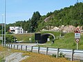
 View of the north entrance to the tunnel | |
| Overview | |
|---|---|
| Location | Sør-Trøndelag, Norway |
| Coordinates | 63°30′04″N 9°05′51″E / 63.5010°N 9.0974°E |
| Route | Norwegian National Road 714 |
| Operation | |
| Opened | 8 December 1994 |
| Traffic | Automotive |
| Technical | |
| Length | 5,645 metres (18,520 ft) |
| No. of lanes | 3 |
| Lowest elevation | −264 metres (−866 ft) |
| Grade | 10% |
The Hitra Tunnel (Norwegian: Hitratunnelen) is an undersea tunnel connecting the island municipality of Hitra to the mainland municipality of Snillfjord in Sør-Trøndelag county, Norway. The tunnel is 5,645 metres (18,520 ft) long and reaches a depth of 264 metres (866 ft) below sea level, making it the deepest tunnel in the world when it was built.[1][2]
The tunnel begins in Hitra on the island of Justenøya, just south of Sandstad. The tunnel then runs under the Trondheimsleia to the island of Hemnskjel in Snillfjord. There is a small bridge connecting Hemnskjel to the mainland.
The tunnel has 3 lanes. Nearly 2,500 cars are passing through it every day. Electronics and pumps are handling over 10,000 gallons of water per hour. (Source: Hitra·Frøya Nr. 46, 36. årgang, Tirsdag 21 juni 2011.)
Media gallery
-
 View of the south end of the tunnel
 -
 View of the bridge connecting Hemnskjela to the mainland


References
- ^ Merzagora, Eugenio A.; Lotsberg, Gunnar (eds.). "Road Tunnels in Norway > 3 000 m". Road Tunnels in Norway. Retrieved 2010-12-28.
- ^ Store norske leksikon. "Hitratunnelen" (in Norwegian). Retrieved 2010-12-28.
This Trøndelag location article is a stub. You can help Wikipedia by expanding it. |
This Norwegian tunnel-related article is a stub. You can help Wikipedia by expanding it. |