Kijik, Alaska
Kijik Archeological District | |
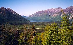
 Scenery in the district | |
| Location | Lake and Peninsula Borough, Alaska, United States |
|---|---|
| Nearest city | Nondalton, Alaska |
| Coordinates | 60°17′33″N 154°15′1″W / 60.29250°N 154.25028°W |
| Area | 1,920 acres (780 ha) |
| NRHP reference No. | 94001644 |
| Significant dates | |
| Added to NRHP | October 12, 1994[1] |
| Designated NHLD | October 12, 1994[2] |
Kijik is a ghost town in Lake and Peninsula Borough, Alaska, United States. An Athabascan village that was established on the shores of Lake Clark in the Alaska Range, its population was recorded at 91 in the 1880 United States Census and declined thereafter, falling to approximately 25 individuals by 1904. Today, the village has been abandoned. The ghost town is located at 60°17′28″N 154°13′0″W / 60.29111°N 154.21667°W, at an elevation of 259 feet (79 m);[3] it is located within the bounds of Lake Clark National Park and Preserve.
The historic portion of the village was the subject of archaeological and ethnological research in the 1960s. Interviews with Dena'ina elders in Nondalton established that the people of Kijik relocated to Old Nondalton (not far from present-day Nondalton) in the early 19th century, probably to be closer to trading posts and the canneries of Bristol Bay. A survey expedition that visited the site in 1909 reported it to be abandoned. A major archaeological excavation of the historic village took place in 1966, exposing twelve foundational remnants of log houses (many of the houses having apparently been moved to Old Nondalton at the time of the relocation), and two of what appeared to be larger communal structures.[4]
In 1979, twelve acres of the village site were added to the National Register of Historic Places as a historic district.[1] A much larger area, encompassing a significant number of archaeological sites related to the habitation and use of the area from at least the 12th century forward, was designated a National Historic Landmark District in 1994, for the unique concentration of sites related to the inland Dena'ina people.[2][5]
The community was known by many other names than "Kijik" during its history, including "Lake Clark Village", "Nijik", "Nikhkak", "Nikhak", and "Old Keegik". Its current name has been spelled in a wide variety of ways, including "Keechik", "Keeghik", "Keejik", "Keggik", "Keygik", "Kichak", "Kichik", "Kilchik", and "Kilchikh".[3]
See also
- List of National Historic Landmarks in Alaska
- National Register of Historic Places listings in Lake and Peninsula Borough, Alaska
- National Register of Historic Places listings in Lake Clark National Park and Preserve
References
- ^ a b c "National Register Information System". National Register of Historic Places. National Park Service. March 13, 2009.
- ^ a b "Kijik Archeological District". National Historic Landmark summary listing. National Park Service. Retrieved 2008-01-04.
- ^ a b U.S. Geological Survey Geographic Names Information System: Kijik, Alaska
- ^ Vanstone, James; Townsend, Joan (January 16, 1970). "Kijik: An Historic Tanaina Settlement". Fieldiana. Anthropology (Volume 15): 1–202. JSTOR 29782443.
{{cite journal}}:|issue=has extra text (help) - ^ "National Park Service Cultural Landscapes Inventory Professional Procedures Guide" (PDF). National Park Service. Retrieved 2014-12-05.
- Geography of Lake and Peninsula Borough, Alaska
- Ghost towns in Alaska
- Inuit history
- National Historic Landmarks in Alaska
- Buildings and structures in Lake and Peninsula Borough, Alaska
- Native American history of Alaska
- Historic districts on the National Register of Historic Places in Alaska
- National Register of Historic Places in Lake and Peninsula Borough, Alaska
- Populated places on the National Register of Historic Places in Alaska
- Archaeological sites on the National Register of Historic Places in Alaska


