
Kongōbu-ji
| Kongōbu-ji 金剛峰寺 | |
|---|---|
 | |
| Religion | |
| Affiliation | Kōyasan School of Shingon Buddhism |
| Deity | Ashuku Nyorai (Akṣobhya) |
| Location | |
| Location | 132 Kōyasan, Kōya-chō, Ito-gun, Wakayama Prefecture |
| Country | Japan |
| Architecture | |
| Founder | Kūkai |
| Completed | 816 |
| Website | |
| http://www.shukubo.net/ | |
Kongōbu-ji (金剛峯寺) is the ecclesiastic head temple of Koyasan Shingon Buddhism, located on Mount Kōya (高野山, Kōya-san), Wakayama prefecture, Japan. Its name means Temple of the Diamond Mountain. It is part of the "Sacred Sites and Pilgrimage Routes in the Kii Mountain Range" UNESCO World Heritage Site.
The temple was first constructed as Seigan-ji Temple in 1593 by Toyotomi Hideyoshi on the death of his mother, rebuilt in 1861, and given its present name in 1869. It contains many sliding screen doors painted by Kanō Tanyū (1602-1674) and members of Kyoto's Kanō school.
The temple's modern Banryūtei (蟠龍庭) rock garden is Japan's largest (2340 square meters), with 140 granite stones arranged to suggest a pair of dragons emerging from clouds to protect the temple.
As of 2013[update] the 412th abbot Yukei Matsunaga, who also acts as the supreme archbishop of the Koyasan Shingon sect, was incumbent.
Gallery
-
 Approach
 -
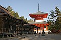 Konpon Daitō,
the central pagoda -
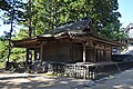
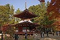
 Kondō,
the main hall of Mt. Kōya -
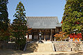
 Fudōdō,
a National Treasure -
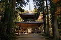 Saitō, the west pagoda
 -
 Tōtō, the east pagoda
 -
 Mieidō
 -
 Sannō-in
 -
 Banryūtei rock garden


See also
- List of National Treasures of Japan (temples)
- List of National Treasures of Japan (ancient documents)
- List of National Treasures of Japan (paintings)
- List of National Treasures of Japan (sculptures)
- List of National Treasures of Japan (writings)
- List of National Treasures of Japan (crafts-others)
- Tourism in Japan
References
- Japan Visitor article
- Wakayama Prefecture article
- Alison Main, Newell Platten, The Lure of the Japanese Garden, W. W. Norton & Company, 2002, page 46. ISBN 0-393-73091-3.
- Dorothy Perkins, Encyclopedia of Japan: Japanese History and Culture, from Abacus to Zori, "Kongobuji" article, Facts on File, 1991, page 182. ISBN 0-8160-1934-7.
External links
34°12′51″N 135°35′03″E / 34.214081°N 135.584092°E
This Buddhism-related article is a stub. You can help Wikipedia by expanding it. |
This article related to religion in Japan is a stub. You can help Wikipedia by expanding it. |
This article about a Japanese building- or structure-related topic is a stub. You can help Wikipedia by expanding it. |