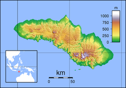
Laiwangi Wanggameti National Park
| Laiwangi Wanggameti National Park | |
|---|---|
| Location | Sumba, Indonesia |
| Coordinates | 10°4′0″S 120°11′0″E / 10.06667°S 120.18333°E |
| Area | 470.14 km2 |
| Established | 1998 |
| Governing body | Ministry of Forestry |
Laiwangi Wanggameti National Park is located on the island of Sumba in Indonesia. All forests types that exist on this island can be found in this national park. Some endemic plant species are protected in this national park, such as Syzygium species, Alstonia scholaris, Ficus species, Canarium oleosum, Cinnamomum zeylanicum, Myristica littoralis, Toona sureni, Sterculia foetida, Schleichera oleosa, and Palaquium obovatum.[1]
Animal species being protected in this national park include the crab-eating macaque, Sus species, water monitor, Python timoriensis, red junglefowl, red-naped fruit-dove, Sumba green pigeon, Sumba buttonquail, citron-crested cockatoo, purple-naped lory, Sumba flycatcher, Sumba cicadabird, and apricot-breasted sunbird.[1]
See also
References
- ^ a b Indonesian Department of Forestry: Laiwangi-Wanggameti National Park, retrieved 6 July 2011

