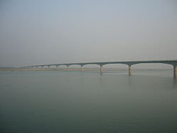
Lalon Shah Bridge
Appearance
Lalon Shah Bridge লালন শাহ সেতু | |
|---|---|
 | |
| Coordinates | 24°03′54″N 89°01′45″E / 24.065°N 89.029167°E |
| Crosses | Padma |
| Locale | Pabna and Kushtia |
| Characteristics | |
| Total length | 1.8 km (1.1 mi) |
| Width | 18.10 m (59.4 ft) |
| History | |
| Opened | 18 May 2004 |
| Location | |
 | |
Lalon Shah Bridge (Bengali: লালন শাহ সেতু), also known as the Paksey Bridge, is a road bridge in Bangladesh over the river Padma, situated between Ishwardi Upazila of Pabna on the east, and Bheramara Upazila of Kushtia on the west. Named after early 19th century mystic poet Lalon Shah of Chhewuriya, Kushtia District, the bridge was completed in 2004.
The bridge is 1,800 metres (5,900 ft) long[1] and is the fourth longest road bridge of the country, after Jamuna Bridge, Meghna Bridge and Meghna-Gomti bridge. It provides important road connection to Mongla port of Khulna District in the south from Rajshahi division and Rangpur division, the northern part of Bangladesh.
It is situated parallel to and south (downstream) of Hardinge Bridge.
Gallery
References
Wikimedia Commons has media related to Lalon Shah Bridge.
- ^ "Lalon Shah Bridge". Structurae. Wilhelm Ernst and Sohn Verlag. 22 July 2014. Retrieved 17 October 2014.


