Lamington, Queensland
| Lamington Queensland | |||||||||||||||
|---|---|---|---|---|---|---|---|---|---|---|---|---|---|---|---|
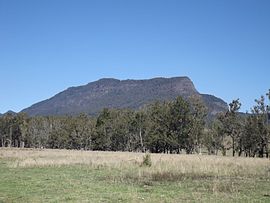
 Mount Widgee, 2014 | |||||||||||||||
| Coordinates | 28°16′05″S 153°01′28″E / 28.2680°S 153.0244°E | ||||||||||||||
| Population | 89 (2021 census)[1] | ||||||||||||||
| • Density | 1.529/km2 (3.961/sq mi) | ||||||||||||||
| Established | 1997 | ||||||||||||||
| Postcode(s) | 4285 | ||||||||||||||
| Area | 58.2 km2 (22.5 sq mi) | ||||||||||||||
| Time zone | AEST (UTC+10:00) | ||||||||||||||
| Location |
| ||||||||||||||
| LGA(s) | Scenic Rim Region | ||||||||||||||
| State electorate(s) | Scenic Rim | ||||||||||||||
| Federal division(s) | Wright | ||||||||||||||
| |||||||||||||||
Lamington is a rural locality in the Scenic Rim Region, Queensland, Australia.[2] In the 2021 census, Lamington had a population of 89 people.[1]
Geography
[edit]Christmas Creek is one of a number of tributaries of the Logan River which have headwaters in the McPherson Range along the border. The upper Christmas Creek valley is mountainous. Peaks at Lamington include Little Widgee Mountain, Bujera in the east while across the valley the slopes rise towards Neglected Mountain. The southern boundary follows a section of the western Lamington Plateau and Lamington National Park.
Lamington has the following mountains and cliffs:
- Buchanans Fort (mountain) (28°17′02″S 153°03′40″E / 28.2839°S 153.0612°E) 817 metres (2,680 ft)[3][4]
- Little Widgee Mountain (28°16′05″S 153°03′01″E / 28.2681°S 153.0504°E) 759 metres (2,490 ft)[3][5]
- Bujera (cliff) (28°18′00″S 153°04′03″E / 28.2999°S 153.0675°E)[6]
- Hillview Cliffs (28°14′38″S 152°58′26″E / 28.2440°S 152.9738°E)[7]
History
[edit]
The name Bujera is an Aboriginal word meaning "warm, love, adore, a good feeling" of the traditional landowners, the Mununjali people. [6]
Willowbank Provisional School opened on 20 August 1906. On 1 January 1909 it became Willowbank State School. On 13 July 1914 it was renamed Lamington State School. It closed in April 1943.[8] The school was on Kerry Road and its site is marked with a monument with a plaque.
Lamington was the terminus for one branch of the Beaudesert Shire Tramway. It operated from 1910 to 1944.[9]
Captain Vance of the Royal Australian Survey Corp established a trigonometrical Station on Hillview Cliffs which was in use from 1924 and 1930.[7]
Demographics
[edit]In the 2016 census, Lamington had a population of 86 people.[10] The locality contained 58 households, in which 53.5% of the population were males and 46.5% of the population were females with a median age of 48, 10 years above the national average. The average weekly household income was $1,374, $64 below the national average.[10]
In the 2021 census, Lamington had a population of 89 people.[1]
Education
[edit]There are no schools in Lamington. The nearest primary school is Hillview State School in neighbouring Hillview to the north. The nearest secondary school is Beaudesert State High School in Beaudesert to the north.[11]
See also
[edit]References
[edit]- ^ a b c Australian Bureau of Statistics (28 June 2022). "Lamington (SAL)". 2021 Census QuickStats. Retrieved 28 February 2023.
- ^ "Lamington – locality in Scenic Rim Region (entry 45158)". Queensland Place Names. Queensland Government. Retrieved 29 December 2020.
- ^ a b "Mountain peaks and capes - Queensland". Queensland Open Data. Queensland Government. 12 November 2020. Archived from the original on 25 November 2020. Retrieved 25 November 2020.
- ^ "Buchanans Fort – unbounded locality in the Scenic Rim Region (entry 4877)". Queensland Place Names. Queensland Government. Retrieved 23 February 2021.
- ^ "Little Widgee Mountain – mountain in Scenic Rim Region (entry 19768)". Queensland Place Names. Queensland Government. Retrieved 25 November 2020.
- ^ a b "Bujera – cliff in Scenic Rim Regional (entry 45241)". Queensland Place Names. Queensland Government. Retrieved 29 December 2020.
- ^ a b "Hillview Cliffs – cliff in Scenic Rim Regional (entry 15912)". Queensland Place Names. Queensland Government. Retrieved 29 December 2020.
- ^ Queensland Family History Society (2010), Queensland schools past and present (Version 1.01 ed.), Queensland Family History Society, ISBN 978-1-921171-26-0
- ^ "Hillview Tramway Station Monument". Monument Australia. Archived from the original on 16 April 2016. Retrieved 30 March 2016.
- ^ a b Australian Bureau of Statistics (27 June 2017). "Lamington (SSC)". 2016 Census QuickStats. Retrieved 20 October 2018.
- ^ "Queensland Globe". State of Queensland. Retrieved 3 May 2020.
External links
[edit]![]() Media related to Lamington, Queensland at Wikimedia Commons
Media related to Lamington, Queensland at Wikimedia Commons

