
Lapstone, New South Wales
| Lapstone Blue Mountains, New South Wales | |||||||||||||||
|---|---|---|---|---|---|---|---|---|---|---|---|---|---|---|---|
View_east_from_south_Lapstone-1.jpg) View east from south Lapstone | |||||||||||||||
 Lapstone | |||||||||||||||
 | |||||||||||||||
| Coordinates | 33°46′26″S 150°38′13″E / 33.77389°S 150.63694°E | ||||||||||||||
| Population | 961 (2016 census)[1] | ||||||||||||||
| Postcode(s) | 2773 | ||||||||||||||
| Elevation | 160 m (525 ft) | ||||||||||||||
| Location |
| ||||||||||||||
| LGA(s) | City of Blue Mountains | ||||||||||||||
| State electorate(s) | |||||||||||||||
| Federal division(s) | Macquarie | ||||||||||||||
| |||||||||||||||
Lapstone is a township on the eastern escarpment of the Blue Mountains in New South Wales, Australia. Elevation 160 m (525 ft). Lapstone is located 62 kilometres west of the Sydney CBD in the local government area of the City of Blue Mountains and is part of the federal electorate of Macquarie.[2] Lapstone consists mostly of stand-alone housing and has a few public facilities. At the 2016 census, Lapstone had a population of 961 people.[3] Lapstone was originally bought and developed by Mr Arthur J Hand, an Alderman of the Blue Mountains City Council.
Lapstone is the first town in the easternmost escarpment of the Blue Mountains. Its name comes from the many water worn stones in the area that resemble those used by cobblers to work the leather when making shoes.
History
[edit]Blaxland Lawson and Wentworth, were the first Europeans to explore the Lapstone area, climbing up the Lapstone Hill and reaching Glenbrook Lagoon on 12 May 1813, on their successful trek across the Great Dividing Range.
The first road was built by William Cox and a gang of convicts, up the Lapstone Hill through Lapstone and across the Blue Mountains, about 1815. (A plaque on the site of the old Cox Road can be seen off Governor Drive at the M4 junction). The Cox road was replaced by "The Western Road" across Lennox Stone Bridge and up the Lapstone Hill in 1833 and, following the railway in 1867, "The Great Western Highway". The Highway is now the main road up Lapstone Hill and across the Blue Mountains.
The Lapstone Zig Zag
[edit]The Lapstone Zig Zag line (or "little" zig zag) opened near Glenbrook in 1867. The ascent of Lapstone Hill on a gradient of 1 in 30-33, was built up the side of the range with comparatively light earthwork, includes the substantial seven-span sandstone Knapsack Viaduct. The viaduct was later widened to carry the old Great Western Highway, when the deviation around the Lapstone Zig Zag was built. The zig zag is now part of a walking trail on the old railway/highway alignment, including a memorial to John Whitton, the engineer in charge of the construction of the Blue Mountains line and many other early railways.[4] One feature of this line was the Lucasville platform built by John Lucas to access his property at Lapstone. Remains of it can still be seen.
The Lapstone Tunnel
[edit]
A new route was opened on 18 December 1892 to avoid the Lapstone Zig Zag.[5] After crossing the viaduct, the new line curved around to the west and went through a new tunnel, the Lapstone Tunnel. The tunnel emerged further west near the Great Western Highway with a total of 660 metres in length. The tunnel can still be seen from neighbouring bush tracks.[6] The new tunnel was hailed as a major improvement, but problems with ventilation and water from the nearby creek lead to trains getting stuck. The Lapstone Tunnel was finally closed and replaced 24 September 1913.[7]
The abandoned Lapstone Tunnel was used by the nearby RAAF base during World War II as storage for arms such as bombs and mustard gas. The RAAF laid a concrete floor for better storage and access. It has also been used to grow mushrooms.[5]
The Glenbrook Tunnel
[edit]In 1913, the present route was constructed to bypass the Lapstone tunnel, going along the escarpment of Glenbrook Gorge and through a new tunnel at the spot known as The Bluff. One of the features of this project was the construction of a temporary railway line that crossed Darks Common south of Explorers Road. The rail line has been removed but the cutting can still be seen, as well as the remains of the winding house base near the escarpment.[8] This was known as the Spur-line and was in operation from 1911 until 1913, the line and cutting now forming a part of a nature walk through Darks Common. The Glenbrook Tunnel, 282 metres in length, came into operation on 11 May 1913, and is still used today.[9]
The Lapstone Hill Hotel
[edit]The land occupied by the present RAAF base was originally owned in the 1870s by John Lucas (1818 - 1902), He built a country retreat on the land called Lucasville, close to his private Lucasville railway station, but sold the property to Charles Smith. Smith built his own house, called Logie, higher up the hill, above the railway and Lucas’s little cottage. Charles Smith died in 1897. Logie house and estate was inherited by his son Colin. In 1921 Logie and its estate were bought by Herwold Kirkpatrick and his brother-in-law. Kirkpatrick was a well known architect and from the late 1920s he set out to transform the Logie Cottage and grounds into a luxury Hotel.
The Lapstone Hill Hotel was officially opened in 1930 and was a major Art Deco luxury hotel. The grounds of some 6 hectares (15 acres) were ‘tastefully planned with lawns, flowers, fruit and vegetable gardens, with water pumped from the Nepean River far below. The Hotel had great views of the Nepean River and offered views of the Sydney metropolis. The hotel was extremely fashionable all throughout the 1930s. The Hotel was noted for adverting the benefits of the mountain environment on ones health, and attracted many people from Sydney that wanted to escape the city life.
In 1949 the Lapstone Hill Hotel and grounds were offered to the Commonwealth Department of Defence as a new headquarters for the RAAF’s Eastern Area Command, the RAAF Base Glenbrook. No personnel actually lived in the 57 rooms of the former hotel during the first twenty years of RAAF use, but in 1982 a new administration block was opened and the former hotel became entirely the Officers’ Mess: about 35 officers were then accommodated in the upper storey. Downstairs suites are used for visiting VIPs and were created in 1994 by the architect Robert Staas and the interior designer Elizabeth Mackie, retaining the Art Deco theme[10]
The New Lapstone Hotel
[edit]The New Lapstone Hotel was built in the 1950s further up the Great Western Highway at Blaxland, after The Lapstone Hill Hotel and grounds was purchased by the RAAF. The Hotel was called "The New Lapstone Hotel" up until the 1980s.
Today the hotel is known as The Lapstone Hotel, It was renovated in 2007 after being purchased by the Lewis Group of Hotels.[11]
Housing Development
[edit]The Suburb of Lapstone was developed in the 1960s, Mr Arthur J Hand, an alderman of the Blue Mountains Council bought the land to develop the suburb. The Railway Station was opened in 1964 to service the new housing estate.
Darks Common
[edit]Darks Common became a public reserve in the 1970s to prevent further housing development. The leading voice in the conservation of the area was local Micheal Dark, son of author Eleanor Dark and her husband Dr Erick Dark. The reserve now protected by council bears the name of the family.[12]
There are many walking tracks throughout the common, the Spur-Line walking track leads to the Glenbrook Creek and views of Glenbrook Gorge at Bluff lookout. Lapstone Oval is located inside Darks Common.
Population
[edit]In the 2016 Census, there were 961 people in Lapstone. 81.0% of people were born in Australia and 87.7% of people spoke only English at home. The most common responses for religion were No Religion 30.0%, Catholic 24.9% and Anglican 18.9%.[1]
Gallery
[edit]-
 Remains of Lucasville Station on the Zig Zag line
 -
 Glenbrook Tunnel constructed in 1892, Eastern Entrance.
 -
 Cutting where the construction railway line went through Darks Common, The Spurline.
 -
 Remains of winding house base at the south end of the construction railway line
 -
 Lapstone Railway Station Building.
 -
 Old Brick Kiln
 -
 George Evans Memorial, Lapstone
 -
 Governors Drive, where it joins the M4
 -
 View from Bluff Lookout, Glenbrook Gorge.

1892_railway_tunnel_Lapstone.jpg)
1913_construction_railway_Darks_Common.jpg)
construction_railway_winding_house_base_Lapstone-2.jpg)

old_brick_kiln_Governors_Drive_Lapstone.JPG)
George_Evans_Memorial_Lapstone.JPG)

View_east_from_south_Lapstone-2.jpg)
Public Transport
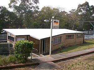
[edit]Lapstone railway station is on the Blue Mountains Line of the NSW TrainLink interurban network. Lapstone can be accessed by road from the Great Western Highway/M4 Motorway by exiting at Governors Drive and Explorers Road from Glenbrook. The station was built by R&K McGraw Builders sub contracting bricklayer Frank Davis of Lapstone.
Lapstone Railway Station, was officially opened on 24 February 1964.[13]
The area is also serviced by buses.
Education
[edit]- Lapstone Public School, opened in 1971.[14]
- Jean Ranft (later Jean Jones) single-handedly took on various government departments to gain funding for a one-room (plus toilets and kitchen) concrete-block building, and also took on some of the construction work, along with the rest of the Ranft family and other members of the Lapstone community. Jean is pictured with the first class in 1971. You can see the regrowth in the bushland after the devastating 1968 bushfires.
Sport and Recreation
[edit]Lapstone Netball Courts[15] are home to Lapstone Glenbrook Netball Club. There are 9 asphalt courts, and 2 grass courts at the complex, including a clubhouse and BBQ area. All clubs form the Blue Mountains Netball Association play matches at the complex on Saturdays. Netball is the largest participation sport in the Blue Mountains.
Founded in 1975, Lapstone Glenbrook Netball Club[16] was formed from a merger between what was St Peter's Netball Club and school-based teams at Lapstone Public School[17] and Glenbrook Public School.[18] St Peter's Netball Club was a founding club of the Blue Mountains Netball Association[19] and was run from the church organisation previously based in the St Peter's Anglican Church building which is now used as a cafe in Glenbrook).
Lapstone Oval is home to the Blue Mountains District Rugby Football Club, and its junior club Blue Tongues Rugby, featuring a Rugby Union field, an artificial cricket pitch.[20]
Glenbrook/Blaxland Cricket Club play matches on the oval in the summer months.
There are 2 Tennis Courts at Lapstone Oval, and children's play equipment.
References
[edit]- ^ a b Australian Bureau of Statistics (27 June 2017). "Lapstone (State Suburb)". 2016 Census QuickStats. Retrieved 24 April 2018.
- ^ "Archived copy" (PDF). Archived (PDF) from the original on 2 June 2011. Retrieved 9 August 2011.
{{cite web}}: CS1 maint: archived copy as title (link) - ^ Australian Bureau of Statistics (27 June 2017). "Lapstone (State Suburb)". 2016 Census QuickStats. Retrieved 25 April 2018.
- ^ "Bridges around the Penrith Area". Penrith City Council. 4 April 2006. Archived from the original on 24 March 2012. Retrieved 5 April 2012.
- ^ a b Martin, David. "Lapstones's old Railway Tunnel - Blue Mountains". infobluemountains.net.au. Blue Mountains Railway Pages. Archived from the original on 9 October 2017. Retrieved 28 October 2017.
- ^ How to See the Blue Mountains, Jim Smith (Second Back Row Press) 1986, p.74
- ^ "Glenbrook Tunnel (1st)". www.nswrail.net. Archived from the original on 20 May 2018. Retrieved 20 May 2018.
- ^ How to See the Blue Mountains, p. 75.
- ^ "Glenbrook Tunnel". www.nswrail.net. Archived from the original on 20 May 2018. Retrieved 20 May 2018.
- ^ "G030 : Lapstone Hotel (RAAF Base), Former | NSW Environment & Heritage". www.environment.nsw.gov.au. Archived from the original on 18 August 2017. Retrieved 27 May 2018.
- ^ "Lapstone Hotel Website". Archived from the original on 25 January 2014. Retrieved 14 February 2014.
- ^ "G005 : The Spurline | NSW Environment & Heritage". www.environment.nsw.gov.au. Retrieved 2 June 2018.
- ^ "Lapstone Station". www.nswrail.net. Archived from the original on 20 May 2018. Retrieved 20 May 2018.
- ^ "Lapstone Public School". www.lapstonepublic.com.au. Archived from the original on 21 May 2018. Retrieved 20 May 2018.
- ^ "Lapstone Netball Courts on Google Maps".
- ^ "Lapstone Glenbrook Netball Club".
- ^ "Lapstone Public School". www.lapstonepublic.com.au. Archived from the original on 21 May 2018. Retrieved 20 May 2018.
- ^ "Glenbrook Public School".
- ^ "Blue Mountains Netball Association".
- ^ "Blue Mountains Rugby". www.bluemountains.rugby.net.au. Archived from the original on 19 March 2019. Retrieved 16 March 2019.