Maryina Horka
Appearance
Maryna Horka / Marina Gorka Ма́р'іна Го́рка / Марьина Горка | |
|---|---|
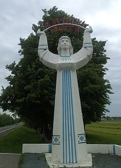
 Monument of Maria - symbol of Mar`ina Horka | |
| Coordinates: 53°30′25.92″N 28°09′07.92″E / 53.5072000°N 28.1522000°E | |
| Country Voblast Raion | Pukhavichy Raion |
| Founded | 1222 |
| Area | |
| • Total | 8.2 km2 (3.2 sq mi) |
| Elevation | 169 m (554 ft) |
| Population (2009) | |
| • Total | 21,446 |
| • Density | 2,600/km2 (6,800/sq mi) |
| [1] | |
| Time zone | UTC+2 (EET) |
| • Summer (DST) | UTC+3 (EEST) |
| Postal code | 222811 |
| Area code | +375 1713 |
| License plate | 5 |
| Website | Official website |
Maryina Horka (Belarusian: Ма́р'іна Го́рка, Russian: Марьина Горка, Maryina Gorka, Polish: Maryjna Górka) is a town in Minsk Voblast, Belarus, the capital of the Pukhavichy Raion. As of 2009 its population was 22,500.[2]
Maryina Horka is located 60 km (37.28 mi) south of Minsk. It is traversed by the M5 highway, between Minsk and Babruysk.
History
The town was first mentioned in 1222 and received its town (Город, Gorod) status in 1955. The 5th Spetsnaz Brigade, first of the Soviet Spetsnaz GRU, now of the Armed Forces of Belarus, has been located here since 1963.
See also
References
- ^ "World Gazeteer". Archived from the original on 2013-01-11.
{{cite web}}: Unknown parameter|deadurl=ignored (|url-status=suggested) (help) - ^ Template:Ru icon 2009 statistics of Belarus (Belstat)
External links
![]() Media related to Maryina Horka at Wikimedia Commons
Media related to Maryina Horka at Wikimedia Commons
- Template:Ru icon Maryina Horka official website
- The murder of the Jews of Maryina Horka during World War II, at Yad Vashem website.
53°30′25.92″N 28°09′07.92″E / 53.5072000°N 28.1522000°E


