Negrar di Valpolicella
Appearance
Negrar | |
|---|---|
| Comune di Negrar | |
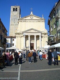
 Church in Negrar. | |
| Country | Italy |
| Region | Veneto |
| Province | Verona (VR) |
| Frazioni | Arbizzano, Jago, Fane, Mazzano, Montecchio, Prun, Santa Maria, Torbe |
| Government | |
| • Mayor | Giorgio Dal Negro |
| Area | |
• Total | 40.5 km2 (15.6 sq mi) |
| Elevation | 190 m (620 ft) |
| Population (2015)[2] | |
• Total | 17,119 |
| • Density | 420/km2 (1,100/sq mi) |
| Demonym | Negraresi |
| Time zone | UTC+1 (CET) |
| • Summer (DST) | UTC+2 (CEST) |
| Postal code | 37024 capoluogo, 37020 frazioni |
| Dialing code | 045 |
| Website | Official website |
Negrar is a comune (municipality) in the Province of Verona in the Italian region Veneto, located about 110 kilometres (68 mi) west of Venice and about 12 kilometres (7 mi) northwest of Verona.
History
In prehistoric times, it was a center of the Arusnati, a not well-known population of perhaps mixed origins. In the Middle Ages it was a free commune until it was acquired by the Scaliger of Verona (14th century). Later it was part of the Republic of Venice, under which, in 1791, it received the right to hold a livestock market.
Economy
Negrar and its villages are mainly devoted to agricultural, with production of cherries, vine and fruit, and of wines such as Valpolicella, Amarone and Recioto.
Notable people
- Matteo Manassero - professional golfer
- Pietro Boselli - engineer, former mathematician and model
- Davide Formolo (1992-) - cyclist
References
- ^ "Superficie di Comuni Province e Regioni italiane al 9 ottobre 2011". Italian National Institute of Statistics. Retrieved 16 March 2019.
- ^ All demographics and other statistics: Italian statistical institute Istat.
External links

