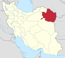
Nishapur County
Nishapur County
Nüşadür شهرستان نیشابور | |
|---|---|
 Mount Binalud, located within the county. | |
 Razavi Khorasan counties | |
 Location of Razavi Khorasan Province in Iran | |
| Coordinates: 36°12′N 58°45′E / 36.200°N 58.750°E | |
| Country | |
| Province | Razavi Khorasan Province |
| Capital | Nishapur |
| Bakhsh (Districts) | Central District, Sarvelayat District, Zeberkhan District, Miyan Jolgeh District |
| Government | |
| • Farman dar | Mozaffari , qolam hossein |
| Population (2011) | |
| • Total | 433,104 |
| Time zone | UTC+3:30 (IRST) |
| • Summer (DST) | UTC+4:30 (IRDT) |
| Nishapur County at GEOnet Names Server | |
Nishapur County (Persian: شهرستان نیشابور, Šahrestâne Nišâpur) is a county in Razavi Khorasan Province in Iran. The capital of the county is Nishapur. At the 2011 census, its population was 433,104, in 118,214 families; excluding those portions.[1]
The county includes the following four districts: Central District, Sarvelayat District, Zeberkhan District, and Miyan Jolgeh District.
The county has six cities: Chekneh, Kharv, Darrud, Eshqabad, Qadamgah, Nishapur & Bar.
Nishapur massacre by the Mongols
The Nishapur massacre by the Mongols took place at Nishapur in April 1221. The Mongol armies of Genghis Khan massacred the entire population of the area, which some estimates put at 1,747,000 citizens.[2]
References
- ^ "Census of the Islamic Republic of Iran, 1390 (2011)". Islamic Republic of Iran. Archived from the original (Excel) on 2016-10-06.
- ^ DEATH BY GOVERNMENT
- اطلس گیتاشناسی استانهای ایران [Atlas Gitashenasi Ostanhai Iran] (Gitashenasi Province Atlas of Iran)

