
North West Tunisia
North-West Tunisia is one of the six geographic and economic regions of the country, it consists of four governorates : Béja, Kef, Siliana and Jendouba. The region had a population of 1,170,752[1] representing 12.2% of the total population of Tunisia, which making it the 4th most populous region in the country after Grand Tunis, the Central East and the Central West
Geography
The North-West region is located in the extreme north of the country, bounded to the west by the Tunisian-Algerian border and to the east by Grand Tunis and the North-East region. In the north, the region is bounded by the Mediterranean Sea (with a 51 km long coast) and Bizerte Governorate and to the south by the Central-West Region.

The region is divided by half by the Medjerda River which is the longest river in the country. The North-West is characterized by its unique forests and mountains (the Khroumire and Mogod Mountains), coral coasts and the large plains.
-
 Tabarka Coast
 -
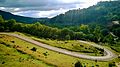 A road in Bni Mtir
 -
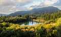 A small lake in Ain Drahem
 -
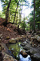
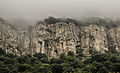
 A mountain forest in Ain Drahem
 -
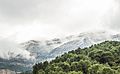
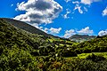 A mountain in Nefza
.jpg)


There are three national parks in the North-West, some of them are entirely in the region and some are partially in it: El Feidja National Park in Jendouba, Jebel Serj National Park sheared between Siliana and Kairouan and the Jebel Chitana-Cap Négro National Park divided between Béja and Bizerte.
-
 Jebel Chitana-Cap Négro National Park
 -
 Jebel Chitana-Cap Négro National Park
 -
 El Feidja National Park
 -
 Jebel Serj National Park
 -
 Jebel Serj National Park


Demographics
With 1,170,752[1] people, the North West is the fourth most populous region in the country. The most populated Governorates of the North West are:
| Governorate | Population (2014) | Population Density | Largest town/city |
|---|---|---|---|
| Jendouba | 401,477 | 130/km² | Jendouba (113,116) (2014 est.) |
| Béja | 303,032 | 81/km² | Béja (109,299) |
| El Kef | 243,156 | 49/km² | El Kef (73,706) |
| Siliana | 223,087 | 48/km² | Siliana (59,140) |
The region is characterized by its rurality. In 2004 only 37,1% live in the cities (compared to 64,9% nationwide).[2] This can be explained by the dominance of the agricultural sector in the region's economy. The region is also marked by its negative net migration of -45,300 between 1999 and 2004.[3]
Cities and towns
Despite the region's rurality, there are several cities and towns:


Population > 100,000
Population > 50,000
Population > 40,000
Population > 20,000
Population > 10,000
Social deprivation
Since several years ago the North West has become one of the poorest region in Tunisia; it registers of the highest rates of poverty, unemployment and illiteracy in the country.
References
- ^ a b Template:Fr Census 2014 (National Institute of Statistics) Archived 2014-10-29 at the Wayback Machine
- ^ http://www.odno.nat.tn/en/index.php?id=17[dead link]
- ^ "Statistiques Tunisie". احصائيات تونسية. Retrieved 9 August 2018.
Governorates and regions of Tunisia | ||
|---|---|---|
| Governorates | ||
| Regions | ||