
Ogunquit, Maine
Ogunquit, Maine | |
|---|---|
 Beachmere Inn | |
| Motto: "Beautiful place by the sea." | |
| Country | United States |
| State | Maine |
| County | York |
| Incorporated | 1980 |
| Area | |
| • Total | 4.3 sq mi (11.1 km2) |
| • Land | 4.1 sq mi (10.6 km2) |
| • Water | 0.2 sq mi (0.5 km2) |
| Elevation | 141 ft (43 m) |
| Population (2000) | |
| • Total | 1,226 |
| • Density | 299.0/sq mi (115.5/km2) |
| Time zone | UTC-5 (Eastern (EST)) |
| • Summer (DST) | UTC-4 (EDT) |
| ZIP code | 03907 |
| Area code | 207 |
| FIPS code | 23-54980 |
| GNIS feature ID | 0582646 |
| Website | www.townofogunquit.org |
Ogunquit (pronounced ⫽oʊˈɡʌŋkwɨt⫽ oh-GUN-kwit) is a town in York County, Maine, United States. As of the 2000 census its population was 1,226. The popularity of the town as a summer resort is epitomized by its motto, "Beautiful Place by the Sea."
Ogunquit is part of the Portland–South Portland–Biddeford, Maine Metropolitan Statistical Area.
History

Ogunquit, which meant "coastal lagoon" to native Abenaki Indians, was first a village within Wells, which was settled in 1641. The first sawmill here was established in 1686, and shipbuilding developed along the tidal Ogunquit River. Besides constructing schooners and brigs, local shipwrights built the famous "Ogunquit dory."
At what was then called Fish Cove, near the unnavigable Josias River, fishing was a major livelihood. But the cove was unprotected by a headland or breakwater from Atlantic storms, so fishermen had to protect their boats by hauling them ashore each night. Resolving to create a safe anchorage, they formed the Fish Cove Harbor Association, and dug a channel across land they purchased to connect Fish Cove with the Josias River. When the trench was complete, in roared the ocean, its erosion helping to further widen the passage. The resulting tidewater basin would be called Perkins Cove, across which spans a manually-operated draw footbridge, possibly one of the most photographed objects in Maine. With a 3 and a half mile beach of pale sand and dunes forming a barrier peninsula, connected to the mainland in 1888 by bridge across the Ogunquit River, the weatherbeaten old village was discovered by artists. It became a popular art colony and tourist area. Particularly after 1898, when the Ogunquit Art Colony was established, it was not unusual to see artists and fishermen plying their respective trades around Perkins Cove. To accommodate summer crowds, several grand seaside hotels and inns were built. Ogunquit is also known for its historical trail known as Marginal Way, which stretches approximately one and one-half miles along the craggy coastline. The walk is scenic, embracing the coast from Perkins Cove to Ogunquit Beach [1]. Today, Ogunquit remains a vibrant seasonal resort town, having separated from Wells in 1980. Visitors often arrive from great distances and in great numbers, some from Canada.
LGBT destination
Over the past 100 years, Ogunquit has become a destination for LGBT tourists, and features numerous LGBT-owned and -operated hotels, restaurants, bars, theaters, and other businesses. Most of the LGBT-oriented businesses are in the Village area of the town.[2]
Education
The Wells-Ogunquit Community School District provides education for students of all ages in the coastal southern Maine towns of Wells and Ogunquit.
Geography
.jpg)
.jpg)
According to the United States Census Bureau, the town has a total area of 4.3 square miles (11.1 km²), of which, 4.1 square miles (10.6 km²) of it is land and 0.2 square miles (0.5 km²) of it (4.43%) is water. Ogunquit is drained by the Josias River and Ogunquit River.
Ogunquit’s Marginal Way,[2] a one and a quarter mile long trail with views of the coast, is neatly paved and the treacherous cliffs are, in places, fenced. The path leads from the downtown shopping area to the fishing village in Perkins Cove, now an outdoor mall of jewelry, clothing and candle boutiques.
Demographics

As of the censusTemplate:GR of 2000, there were 1,226 people, 668 households, and 346 families residing in the town. The population density was 299.0 people per square mile (115.5/km²). There were 2,114 housing units at an average density of 515.6/sq mi (199.1/km²). The racial makeup of the town was 98.53% White, 0.49% African American, 0.08% Native American, 0.49% Asian, 0.08% from other races, and 0.33% from two or more races. Hispanic or Latino of any race were 0.65% of the population.
There were 668 households out of which 10.2% had children under the age of 18 living with them, 46.6% were married couples living together, 3.9% had a female householder with no husband present, and 48.2% were non-families. 39.7% of all households were made up of individuals and 18.1% had someone living alone who was 65 years of age or older. The average household size was 1.84 and the average family size was 2.41.

In the town the population was spread out with 10.4% under the age of 18, 3.5% from 18 to 24, 18.0% from 25 to 44, 37.1% from 45 to 64, and 30.9% who were 65 years of age or older. The median age was 55 years. For every 100 females there were 109.6 males. For every 100 females age 18 and over, there were 106.0 males.
The median income for a household in the town was $47,727, and the median income for a family was $56,731. Males had a median income of $44,583 versus $31,528 for females. The per capita income for the town was $34,289. About 1.2% of families and 4.2% of the population were below the poverty line, including 4.6% of those under age 18 and 3.7% of those age 65 or over.
Trivia
This article contains a list of miscellaneous information. (October 2008) |
- Part of Stephen King's The Stand, published in 1978, is set in Ogunquit.
- No Major League Baseball players have been born in Ogunquit, but one died there: pitcher Bobby Coombs. (d. October 21, 1991)
- The famous radio, stage and movie actor, and husband of Mary-Leigh Call Smart, J. Scott Smart, moved to Ogunquit in 1947 and lived for some years in one of the Perkins Cove fishing cabins where he worked to develop his fine art skills.[citation needed]
Ogunquit was also a summer hideaway and haven for actors like Sally Struthers, Montgomery Clift, Bette Davis and Gary Merrill.[citation needed] Comedienne Totie Fields also had a summer home in Ogunquit; it is now The Admiral's Inn on Route 1.[citation needed]

Cultural sites & museums
- Historical Society of Wells and Ogunquit (1862) (located in Wells)
- Ogunquit Museum of American Art
- Ogunquit Playhouse
- Captain James Winn House (c. 1785)
Notable residents
- John Kendrick Bangs, author
- Walt Kuhn, artist
- Charles H. Woodbury, artist
- Arnie Ginsburg, radio personality
Images
-
 The beach along the Marginal Way, 2008
 -
 The Marginal Way near the Beachmere Hotel, 2008
 -
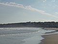 Ogunquit Beach, 2008
 -
 The bridge at Perkins Cove, 2008
 -
 View from the Bridge at Perkins Cove, 2007
 -
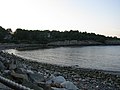 The beach at Perkins Cove looking toward the Marginal Way, 2008


References
- ^ "Marginal Way". Accessed online 22 March 2008
- ^ [1]. Gay Ogunquit. Accessed online 17 July 2008.
External links
- Template:Wikitravel
- Official Website
- Charles H. Woodbury & the Ogunquit School of Art
- Totie Fields' Home in Ogunquit and the Admiral's Inn
- Maine Genealogy: Ogunquit, York County, Maine
Municipalities and communities of York County, Maine, United States | ||
|---|---|---|
| Cities |  | |
| Towns | ||
| CDPs | ||
| Unincorporated communities and villages | ||
| Footnotes | ‡This populated place also has portions in an adjacent county | |