
Põlva County
Põlva County | |
|---|---|
 | |
 Coat of arms | |
 | |
| Country | Estonia |
| Capital | Põlva |
| Government | |
| • Governor | Ulla Preeden |
| Area | |
| • Total | 2,164.77 km2 (835.82 sq mi) |
| Population (Jan 2017[1]) | |
| • Total | 28,507 |
| • Rank | 13th |
| • Density | 13/km2 (34/sq mi) |
| Ethnicity | |
| • Estonians | 95% |
| • other | 5% |
| ISO 3166 code | EE-65 |
| Vehicle registration | O |
| Website | www |

Põlva County (Estonian: Põlva maakond), or Põlvamaa, is one of 15 counties of Estonia. It is situated in south-eastern part of the country and borders Tartu, Valga and Võru counties. The county also shares a common border with Pskov Oblast of Russia. Long sections of the border with neighboring Russia have not yet been ratified by treaty, and certain villages in Põlva County (e.g., Lutepää and Saatse) can only be reached by driving through Russian-controlled territory. 28,507 people live in Põlva County – constituting 2.3% of the total population in Estonia (as of January 2013).[1]
Government
The County Government (Estonian: Maavalitsus) is led by Governor (Estonian: maavanem), who is appointed by the Government of Estonia for a term of five years. Since 2007, the Governor position is held by Priit Sibul.
Municipalities
The county is subdivided into municipalities. There are 3 rural municipalities (Estonian: vallad - parishes) in Põlva County.

| Rank | Municipality | Type | Population (2018)[2] |
Area km2[2] |
Density[2] |
|---|---|---|---|---|---|
| 1 | Kanepi Parish | Rural | 4,864 | 525 | 9.3 |
| 2 | Põlva Parish | Rural | 14,273 | 706 | 20.2 |
| 3 | Räpina Parish | Rural | 6,518 | 591 | 11.0 |
Demographics
27,028 people live in Põlva County – constituting 2.1% of the total population in Estonia (as of January 2013).[1]
Gallery
-
 Pikajärve manor granary
 -
-
 Pikajärve manor
 -
 Räpina manor
 -
 St. Michael's church in Räpina
 -
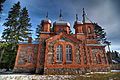 Kärsa orthodox church
 -
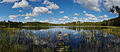
 Lake Kõvverjärv
 -
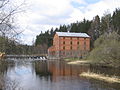 Kiidjärve watermill


References
- ^ a b c "Population by sex, ethnic nationality and County, 1 January". stat.ee. Statistics Estonia. 1 January 2009. Retrieved 18 October 2009.
- ^ a b c "Elanike demograafiline jaotus maakonniti". Kohaliku omavalitsuse portaal. Retrieved 2 April 2018.
External links
58°05′N 27°05′E / 58.083°N 27.083°E
Geographic locale | |
|---|---|