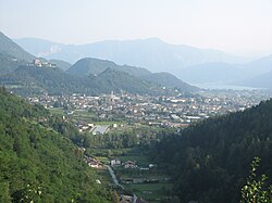
Pergine Valsugana
Appearance
Pergine Valsugana / Fersen im Susanertal | |
|---|---|
| Comune di Pergine Valsugana | |
 | |
| Coordinates: 46°4′N 11°14′E / 46.067°N 11.233°E | |
| Country | Italy |
| Region | Trentino-Alto Adige/Südtirol |
| Province | Trentino (TN) |
| Frazioni | Brazzaniga, Buss, Canale, Canezza, Canzolino, Casalino, Costasavina, Ischia, Madrano, Masetti, Nogaré, Roncogno, San Cristoforo al Lago, Santa Caterina, San Vito, Serso, Susà, Valcanover, Viarago, Vigalzano, Zivignago |
| Government | |
| • Mayor | Roberto Oss Emer |
| Area | |
| • Total | 54.4 km2 (21.0 sq mi) |
| Elevation | 482 m (1,581 ft) |
| Population (28 February 2017)[2] | |
| • Total | 21,433 |
| • Density | 390/km2 (1,000/sq mi) |
| Demonym | Perginesi / Perzenaitri |
| Time zone | UTC+1 (CET) |
| • Summer (DST) | UTC+2 (CEST) |
| Postal code | 38057 |
| Dialing code | 0461 |
| Patron saint | Saint Mary |
| Saint day | September 8 |
| Website | Official website |

Pergine Valsugana (German: Fersen im Suganertal, Pèrzen in local dialect) is a comune (municipality) in Trentino in the northern Italian region Trentino-Alto Adige/Südtirol, located about 9 kilometres (6 mi) east of Trento.
Pergine Valsugana borders the following municipalities: Baselga di Pinè, Trento, Fornace, Sant'Orsola Terme, Civezzano, Frassilongo, Vignola-Falesina, Novaledo, Levico Terme, Tenna, Vigolo Vattaro, Bosentino, Caldonazzo and Calceranica al Lago.
Main sights
- Castle, a medieval fortification on a hill at 657 m above the sea level. It is known from 845, although it could be of Lombard or even late-Roman origins.
- Late Gothic-style church of Santa Maria
- Church of San Carlo, rebuilt in 1619
- Palazzo Tomelin (17th century)
- Palazzo a Prato (16th century)
- Palazzo Gentili-Crivelli (16th century)
- Palazzo Hippoliti (late 15th century)
References
- ^ "Superficie di Comuni Province e Regioni italiane al 9 ottobre 2011". Italian National Institute of Statistics. Retrieved 16 March 2019.
- ^ All demographics and other statistics: Italian statistical institute Istat.
External links
Wikimedia Commons has media related to Pergine Valsugana.
- Official website Template:It icon
- San Cristoforo al Lago, "frazione" in Pergine Valsugana Template:It icon


