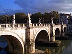
Ponte Pietra (Verona)
Appearance
Ponte Pietra (Pons Marmoreus) | |
|---|---|
 The arch at the far left is the only one which escaped destruction in 1945. | |
| Coordinates | 45°26′52″N 11°00′00″E / 45.447771°N 11°E |
| Crosses | Adige River |
| Locale | Verona, Italy |
| Characteristics | |
| Design | Arch bridge |
| Material | Travertine, brick |
| Total length | 120 m |
| No. of spans | 5 |
| History | |
| Construction end | 100 BC 1957 |
| Closed | April 1945 (4 of 5 spans destroyed) |
| Location | |
 | |
The Ponte Pietra (Italian for "Stone Bridge"), once known as the Pons Marmoreus, is a Roman arch bridge crossing the Adige River in Verona, Italy. The bridge was completed in 100 BC, and the Via Postumia from Genua to the Brenner Pass passed over it.
It originally flanked another Roman bridge, the Pons Postumius; both structures provided the city (on the right bank) with access to the Roman theatre on the east bank. The arch nearest to the right bank of the Adige was rebuilt in 1298 by Alberto I della Scala. Four arches of the bridge were blown up by retreating German troops in World War II, but rebuilt in 1957 with original materials.
Sources
- Galliazzo, Vittorio (1994), I ponti romani. Catalogo generale, vol. Vol. 2, Treviso: Edizioni Canova, pp. 223–226 (No. 456), ISBN 88-85066-66-6
{{citation}}:|volume=has extra text (help) - O’Connor, Colin (1993), Roman Bridges, Cambridge University Press, pp. 93f. (I169), ISBN 0-521-39326-4
See also
External links
![]() Media related to Ponte Pietra (Verona) at Wikimedia Commons
Media related to Ponte Pietra (Verona) at Wikimedia Commons
- Ponte Pietra at Structurae
- Ponte Pietra - 360° Virtual Tour and photos

