Pooncarie
| Pooncarie New South Wales | |
|---|---|
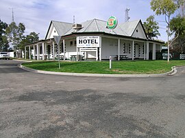
 Pooncarie Hotel | |
| Coordinates | 33°23′S 142°34′E / 33.383°S 142.567°E |
| Population | 328 (2011 census)[1] |
| Established | 1863 |
| Postcode(s) | 2648 |
| Elevation | 56 m (184 ft) |
| Location |
|
| LGA(s) | Wentworth Shire |
| State electorate(s) | Murray |
| Federal division(s) | Farrer |
Pooncarie is a village in south-western New South Wales, Australia in Wentworth Shire. It is on the eastern side of the Darling River between Wentworth and Menindee. The surrounding region of Pooncarie is semi-arid with an outback landscape rich in eucalypt woodlands
History
The region was first settled by Europeans during the 1840s when they took up illegal grazing runs on crown land. During the 1860s the government formalised these illegal (and unfenced) claims in an attempt to gain control of the region. As more settlers followed the town became a service hub for outlying stations. In the mid-19th century, the town’s Darling River wharf was very active as paddle-steamers, carried wool from north-western NSW and south-western Queensland travelling through the port on its way to South Australia.[3]
The Burke and Wills expedition passed through Pooncarie on their journey across Australia from Melbourne to the Gulf of Carpentaria. They reached the Darling River near Tarcoola Station to the south of town on Wednesday, 26 September 1860 and the next day made Camp XXX, (their thirtieth camp since leaving Melbourne) at what is now Bilbarka Park. The expedition stayed here until the morning of 11 October 1860 when they headed north to Menindee.
In 1863 the town was originally gazetted as "Pooncaira".[4]
Pooncarie is approximately 40 kilometres (25 mi) east of, and the closest centre to the burgeoning BEMAX Resources Ginkgo Mineral Sands mine on Malara Station. The mine commenced partial operations in December 2005.[5]
Today the village has a postal centre and centrelink office (which is housed in the former Pooncarie police station), a hotel, a golf course, a tennis court, a general store, a cemetery, and a racecourse, where the Pooncarie Cup - held on Labour Day (NSW and SA) - attracts a crowd of over 1,500 enthusiasts.[6]
Pooncarie is the closest centre to Mungo National Park which is 88 kilometres (55 mi) away, fuel is available at the store reopened July 2013.[7]
See also

References
- ^ Australian Bureau of Statistics (31 October 2012). "Pooncarie (Suburb)". 2011 Census QuickStats. Retrieved 30 March 2015.
- ^ Travelmate Archived 25 March 2007 at the Wayback Machine
- ^ Pooncarie Archived 12 October 2008 at the Wayback Machine Retrieved on 4 July 2009
- ^ Darling River Run – map and guide
- ^ Ginkgo Mineral Sands Project Archived 28 March 2011 at the Wayback Machine Retrieved on 2009-7-4
- ^ Pooncarie Archived 25 April 2009 at the Wayback Machine Retrieved on 4 July 2009
- ^ Pooncarie Retrieved on 4 July 2009
External links
![]() Media related to Pooncarie, New South Wales at Wikimedia Commons
Media related to Pooncarie, New South Wales at Wikimedia Commons
- Burke & Wills Web A comprehensive website containing many of the historical documents relating to the Burke & Wills Expedition.
- The Burke & Wills Historical Society The Burke & Wills Historical Society.
- Pooncarie Cemetery records

