From Wikipedia, the free encyclopedia
Village in Rif Dimashq Governorate, Syria
Qaldoun al-Marah (Arabic: قلدون المراح, also called al-Mirah) is a village in southern Syria, administratively part of the Rif Dimashq Governorate, located on the northeast of Damascus, on the ancient caravan route to Homs and Aleppo, in the Qalamoun Mountains. Nearby localities include Yabroud, an-Nabek, al-Sahel and Deir Atiyah to the north, ar-Ruhaybah, Jayroud, al-Dumayr and al-Qutayfah to the south, and Ma'loula, Assal al-Ward and Hosh Arab to the southwest. According to the Syria Central Bureau of Statistics, Qaldoun al-Marah had a population of 2,561 in the 2004 census.[1]
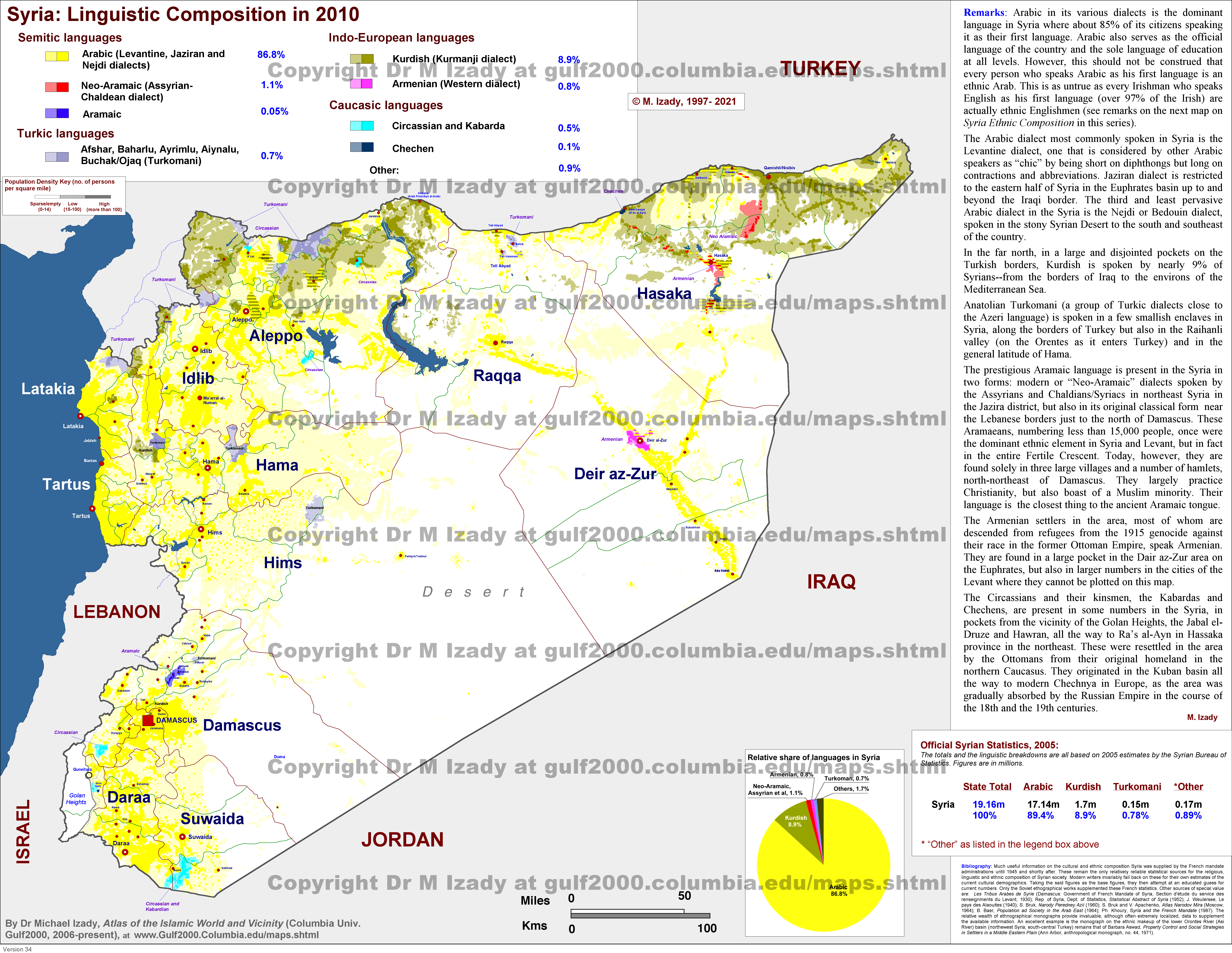
It has a Syrian Turkmen population.[2]
References
|
|---|
|
|---|
Kiswah
Subdistrict | |
|---|
Babbila
Subdistrict | |
|---|
Jaramana
Subdistrict | |
|---|
Malihah
Subdistrict | |
|---|
Kafr Batna
Subdistrict | |
|---|
Arbin
Subdistrict | |
|---|
|
| |
|
|---|
Douma
Subdistrict | |
|---|
Harasta
Subdistrict | |
|---|
Sabe Biyar
Subdistrict | |
|---|
Dumayr
Subdistrict | |
|---|
Nashabiyeh
Subdistrict | |
|---|
Ghazlaniyeh
Subdistrict | |
|---|
Harran al-Awamid
Subdistrict | |
|---|
|
|
|
|---|
Qutayfah
Subdistrict | |
|---|
Jayrud
Subdistrict | |
|---|
Maloula
Subdistrict | |
|---|
Raheiba
Subdistrict | |
|---|
|
|
|
|---|
Al-Tall
Subdistrict | |
|---|
Sednaya
Subdistrict | |
|---|
Rankous
Subdistrict | |
|---|
|
|
|
|---|
Yabroud
Subdistrict | |
|---|
Assal al-Ward
Subdistrict | |
|---|
|
|
|
|---|
An-Nabek
Subdistrict | |
|---|
Deir Atiyeh
Subdistrict | |
|---|
Qara
Subdistrict | |
|---|
|
|
|
|---|
Al-Zabadani
Subdistrict | |
|---|
Madaya
Subdistrict | |
|---|
Serghaya
Subdistrict | |
|---|
|
|
|
|---|
Qatana
Subdistrict | |
|---|
Beit Jann
Subdistrict | |
|---|
Sa'sa
Subdistrict | |
|---|
|
|
|
|---|
Darayya
Subdistrict | |
|---|
Sahnaya
Subdistrict | |
|---|
Hajar al-Aswad
Subdistrict | |
|---|
|
|
|
|---|
Qudsaya
Subdistrict | |
|---|
ad-Dimas
Subdistrict | |
|---|
Ein al-Fijeh
Subdistrict | |
|---|
|
|


