Queen Elizabeth National Park
| Queen Elizabeth National Park | |
|---|---|
 Crater Lake | |
| Location | |
| Nearest city | Kasese |
| Coordinates | 00°12′S 30°00′E / 0.200°S 30.000°E |
| Area | 1,978 square kilometres (764 sq mi) |
| Established | 1954 |
| Governing body | Ugandan Wildlife Authority |
The Queen Elizabeth National Park (QENP) is Uganda's most travelled to national park.[1]
Location
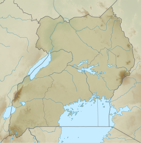
QENP is in western Uganda, spanning the districts of Kasese, Kamwenge, Bushenyi, and Rukungiri. It is approximately 376 kilometres (234 mi), by road, south-west of Kampala, Uganda's capital and largest city.[2] The town of Kasese is just outside the northeastern edge of the park, while the town of Bushenyi is just outside the park's southeastern boundaries.
Overview


QENP occupies an estimated 1,978 square kilometres (764 sq mi).[3] The park extends from Lake George in the north-east to Lake Edward in the south-west and includes the Kazinga Channel connecting the two lakes.
The park was founded in 1952 as Kazinga National Park. It was renamed two years later to commemorate a visit by Queen Elizabeth II.[4]
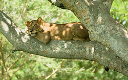
QENP is known for its wildlife, including hippopotami, elephants, African leopards, Congo lions, and chimpanzees. It is home to 95 species of mammal and over 500 species of birds. The area around Ishasha in Rukungiri District is famous for its tree-climbing lions, whose males sport black manes.[5] Poachers killed five or six elephants in the park in 2015, triggering both anger and frustration within the Ugandan conservation community.[6]
The park is also famous for its volcanic features, including volcanic cones and deep craters, many with crater lakes, such as the Katwe craters, from which salt is extracted.[7][8]
QENP includes the Maramagambo Forest and borders the Kigezi Game Reserve, the Kyambura Game Reserve, and the Kibale National Park in Uganda, and the Virunga National Park in the Democratic Republic of the Congo.
QENP and the Queen Elizabeth Country Park in England are twinned in a project of "cultural exchange, mutual support and has its main emphasis on supporting Conservation through working closely with and empowering local communities".[9]
Services in the park include a telecenter run by Conservation Through Public Health[10] and the Uganda Wildlife Authority (neighboring The Queen's Pavilion), park lodges, game and scenic drives, and boat launches.
See also
References
- ^ Queen Elizabeth National Park, Ishasha sector
- ^ "Distance between Kampala () and Mweya Lodge (Kasese) (Uganda)". Retrieved 18 February 2016.
- ^ Uganda Wildlife Authority: http://www.uwa.or.ug/queen.html
- ^ "Queen Elizabeth National Park". Retrieved 18 February 2016.
- ^ "Tree Climbing Lions Ishasha Uganda". Queen Elizabeth National Park Uganda. Retrieved 18 February 2016.
- ^ "Uganda: Queen Elizabeth Park Elephant Deaths". allAfrica.com. 11 January 2016. Retrieved 13 January 2016.
- ^ "Katwe Explosion Crater". Retrieved 18 February 2016.
- ^ "Lake Kwatwe Uganda Safaris". Queen Elizabeth National Park Uganda. Retrieved 18 February 2016.
- ^ http://queenelizabethparks.org/default.aspx/
- ^ "CTPH". Retrieved 18 February 2016.
External links
- QENP Map Uganda Dept of Lands and Surveys, 1961

